Difference between revisions of "2009-07-20 51 12"
imported>Reinhard m (new geohasher) |
imported>Reinhard (hash report) |
||
| Line 6: | Line 6: | ||
}} | }} | ||
| − | [[User:Reinhard|Reinhard]] | + | [[User:Reinhard|Reinhard]] had the choice of going on a 130 km bike expedition (after work!) from Jena to [http://irc.peeron.com/xkcd/map/map.html?date=2009-07-20&lat=51&long=11&zoom=8 51 11 geohash] alone or a <60 km bike expedition from Leipzig to this hashpoint in 51 12 together with [[user:Manu|Manu]]. He decided in favor of Manu and drove to Leipzig after work, where both were starting their expedition by bike. |
| + | Reinhard had already prepared the GPS track, which they just had to follow till Lübschütz, where there already was a rainbow leading the way (You know the story, that you'll always find a geohash at the end of a rainbow?). In Lübschütz Reinhard had a look at the topo map in his Garmin and saw that a forest path was going for 700 m directly to the hashpoint. They followed the path, which was a little tricky considering their road bikes, but after a short while Reinhard stopped, when the geohash was pretty close. He did the GPS dance and reached the coordinates (Manu following him) 20 m beside the path. That was when Roosevelt, Ritchie and (for the first time!) DRomeo climbed out of Reinhard's backpack to be part of the successful hash. | ||
| − | <gallery caption="Photo Gallery" widths="200px" heights="200px" perrow=" | + | When Manu and Reinhard were back in Leipzig after 57 km (taking a detour) at 22:30 it was already dark. |
| + | |||
| + | |||
| + | <gallery caption="Photo Gallery" widths="200px" heights="200px" perrow="3"> | ||
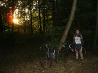
Image:20090720-51N12E_01.jpg|Manu under the rainbow, the hashpoint somewhere there, too. | Image:20090720-51N12E_01.jpg|Manu under the rainbow, the hashpoint somewhere there, too. | ||
Image:20090720-51N12E_02.jpg|Getting off the bike for the last 20 m to the hashpoint. | Image:20090720-51N12E_02.jpg|Getting off the bike for the last 20 m to the hashpoint. | ||
Revision as of 09:27, 21 July 2009
| Mon 20 Jul 2009 in 51,12: 51.3827741, 12.6606590 geohashing.info google osm bing/os kml crox |
Reinhard had the choice of going on a 130 km bike expedition (after work!) from Jena to 51 11 geohash alone or a <60 km bike expedition from Leipzig to this hashpoint in 51 12 together with Manu. He decided in favor of Manu and drove to Leipzig after work, where both were starting their expedition by bike.
Reinhard had already prepared the GPS track, which they just had to follow till Lübschütz, where there already was a rainbow leading the way (You know the story, that you'll always find a geohash at the end of a rainbow?). In Lübschütz Reinhard had a look at the topo map in his Garmin and saw that a forest path was going for 700 m directly to the hashpoint. They followed the path, which was a little tricky considering their road bikes, but after a short while Reinhard stopped, when the geohash was pretty close. He did the GPS dance and reached the coordinates (Manu following him) 20 m beside the path. That was when Roosevelt, Ritchie and (for the first time!) DRomeo climbed out of Reinhard's backpack to be part of the successful hash.
When Manu and Reinhard were back in Leipzig after 57 km (taking a detour) at 22:30 it was already dark.
- Photo Gallery

Manu under the rainbow, the hashpoint somewhere there, too.
Getting off the bike for the last 20 m to the hashpoint.
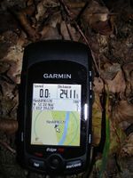
Coordinates.
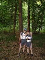
Reinhard, DRomeo, Ritchie, Manu and Roosevelt at the hashpoint.
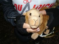
DRomeo's 1st expedition.


