Difference between revisions of "2009-09-13 50 -1"
imported>Sermoa m (→Location: add the satellite image showing the route to the geohash point.) |
imported>Sermoa m (→Location: change the layout so that it fits better on the wiki page.) |
||
| Line 13: | Line 13: | ||
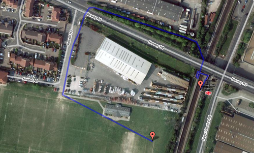
[[Image:2009-09-13_50_-1_route.png | thumb | left| 500px | Walking route from Hilsea train station to the geohash.]] | [[Image:2009-09-13_50_-1_route.png | thumb | left| 500px | Walking route from Hilsea train station to the geohash.]] | ||
| − | + | <br style='clear:left;' /> | |
Thank you [http://www.gmap-pedometer.com/?r=3179897 to gmap-pedometer]. | Thank you [http://www.gmap-pedometer.com/?r=3179897 to gmap-pedometer]. | ||
| − | |||
== Participants == | == Participants == | ||
Revision as of 22:21, 11 September 2009
| Sun 13 Sep 2009 in 50,-1: 50.8275947, -1.0597134 geohashing.info google osm bing/os kml crox |
Contents
Location
Very close to Hilsea train station in Portsmouth. Looks like a field of a recreation centre.
This is an easily accessible geohash in a public place, ideal for a first-time geohash! (hint, hint!)
It's not immediately obvious, but after studying the satellite view for a while, i have determined that this is probably the easiest route to take from the train station to the geohash.
Thank you to gmap-pedometer.
Participants
- Sermoa - confirmed
- Macronencer - possible
Plans
Sermoa will take the train and be at the geohash for 4pm, with my google pin in the ground and wearing an xkcd tshirt. I'll bring food, drink, playing cards, juggling balls, astrojax (if i can find them!), and my xaphoon. I've never stopped in Hilsea before so i'm quite looking forward to having a little look around either before or after the geohash.
Can anyone think of a good way to leave a non-permanent marker of the event? carefully arranged sticks might work ...
