Difference between revisions of "2009-09-25 33 -84"
(New page: {{meetup graticule | map=<map lat="33" lon="-84" date="2009-09-25" /> | lat=33 | lon=-84 | date=2009-09-25 | graticule_name=Atlanta | graticule_link=Atlanta, Georgia }} == Graticule == ...) |
imported>LuxMundi |
||
| Line 32: | Line 32: | ||
<gallery caption="Photo Gallery" widths="200px" heights="200px" perrow="3"> | <gallery caption="Photo Gallery" widths="200px" heights="200px" perrow="3"> | ||
| − | Image: | + | Image:LuxMundi092509-1.JPG| Tracklog |
| + | Image:luxmundi092509-2.JPG| StupidGrin | ||
| + | Image:luxmundi092509-3.JPG| Some of my hitch-hiker friends I picked up. Note to self: always have a change of clothes. | ||
</gallery> | </gallery> | ||
Revision as of 13:36, 29 September 2009
| Fri 25 Sep 2009 in Atlanta: 33.0228332, -84.9926008 geohashing.info google osm bing/os kml crox |
Graticule
About
About 100' off of Davis Road in La Grange, GA.
Expedition
LuxMundi
I took the motorcycle basic rider course this weekend, in Carrollton.
I figured that LaGrange was only "slightly" out of the way, so why not hit a hash?
It took a little while to find a break in the briars, but eventually no problem. The only funny thing was that when I came out of the woods, I was covered with probably 500 "hitchhiker" seeds. I picked some of them off on my way to class, but still had a couple hundred on me all night.
I aced the written test, but barely passed the riding portion. Hopefully I will be able to find an affordable bike and do some hashing that way.
Gallery
- Photo Gallery
- LuxMundi092509-1.JPG
Tracklog
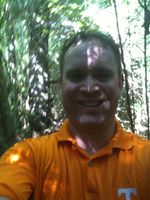
StupidGrin
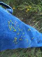
Some of my hitch-hiker friends I picked up. Note to self: always have a change of clothes.


Achievements
LuxMundi earned the Land geohash achievement
|