Difference between revisions of "2009-10-01 35 -106"
imported>Redaragorn |
imported>Redaragorn |
||
| Line 17: | Line 17: | ||
== Plans == | == Plans == | ||
| − | I was planning to head north for some hiking (and probable geohashing) today, but | + | I was planning to head north for some hiking (and probable geohashing) today, but I saw that the local one was a moderately easy one to reach. I knew that there wouldn't be fences or property issues on the west side of Rio Rancho, so I decided that I might as well go for the double hash. |
== Expedition == | == Expedition == | ||
| − | + | We drove west on Southern to the very end of the mesa, then headed south a short distance. Poof, we're there. It was an awfully chilly and windy morning, so we're glad we brought our jackets along. The wind was blowing the sand into everything, which wasn't terribly pleasant. We wandered the couple hundred feet to the hash and got our pictures, then climbed the small hill to the top of the mesa and enjoyed the views down into the Rio Puerco valley beyond before heading on our way. | |
== Pictures == | == Pictures == | ||
Revision as of 00:19, 2 October 2009
| Mon 28 Sep 2009 in 35,-106: 35.3212048, -106.7326484 geohashing.info google osm bing/os kml crox |
Location
In the sagebrush near a small arroyo just outside the Northern Meadows subdivision on the west side of Rio Rancho.
Participants
- Redaragorn and 3 yr old son
Plans
I was planning to head north for some hiking (and probable geohashing) today, but I saw that the local one was a moderately easy one to reach. I knew that there wouldn't be fences or property issues on the west side of Rio Rancho, so I decided that I might as well go for the double hash.
Expedition
We drove west on Southern to the very end of the mesa, then headed south a short distance. Poof, we're there. It was an awfully chilly and windy morning, so we're glad we brought our jackets along. The wind was blowing the sand into everything, which wasn't terribly pleasant. We wandered the couple hundred feet to the hash and got our pictures, then climbed the small hill to the top of the mesa and enjoyed the views down into the Rio Puerco valley beyond before heading on our way.
Pictures
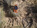
GPS coordinates and suitable XKCD memorial (left at site).

Whew! Remembered to bring my goofy grin with me.
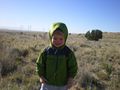
Guess it's not really a drag-along anymore since this is his third one now.


