Difference between revisions of "2009-10-07 48 9"
imported>Ekorren (Categories and a gratuitous ribbon. Report and gallery will both be done later.) |
imported>Ekorren (Gallery) |
||
| Line 21: | Line 21: | ||
== Gallery == | == Gallery == | ||
| − | + | The photographing conditions in the ''Nebelhöhle'' cave were ugly, and I didn't bring a tripod. That means, I had to push the amplifiers above their limits, adding huge lots of noise to the pictures. However, I still think they are worth showing. In the ''Goldloch'' cave, I dared to use the flash for a few pictures. | |
<gallery> | <gallery> | ||
| + | Image:2009-10-07_48_9_Rossberg.jpg|Another Rossberg impression | ||
| + | Image:2009-10-07_48_9_Albtrauf.jpg|Another Albtrauf impression | ||
| + | Image:2009-10-07_48_9_Genkingen.jpg|Reaching hash village | ||
| + | Image:2009-10-07_48_9_GPS.jpg|Coordinates reached | ||
| + | Image:2009-10-07_48_9_Hashpoint.jpg|The actual hashpoint | ||
| + | Image:2009-10-07_48_9_View_from_hash.jpg|View from hashpoint | ||
| + | Image:2009-10-07_48_9_Cross_Road.jpg|On 2006-12-22, Dirk crashed into this slope, 10 m from the hashpoint. | ||
| + | Image:2009-10-07_48_9_Cross.jpg | ||
| + | Image:2009-10-07_48_9_Hash_surroundings.jpg|Surroundings of the hash. It's behind the road in the forest. | ||
| + | Image:2009-10-07_48_9_Nebelhoehle_directions.jpg|Recycled direction sign | ||
| + | Image:2009-10-07_48_9_Toilet_tree.jpg|Official peeing tree (the sign says ''Toiletts'', with no arrow or similar, so it should mean the tree itself, shouldn't it?). | ||
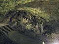
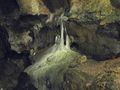
| + | Image:2009-10-07_48_9_Nebelhoehle_1.jpg|Nebelhöhle cave impressions | ||
| + | Image:2009-10-07_48_9_Nebelhoehle_4.jpg | ||
| + | Image:2009-10-07_48_9_Nebelhoehle_5.jpg | ||
| + | Image:2009-10-07_48_9_Nebelhoehle_6.jpg | ||
| + | Image:2009-10-07_48_9_Nebelhoehle_7.jpg | ||
| + | Image:2009-10-07_48_9_Nebelhoehle_8.jpg | ||
| + | Image:2009-10-07_48_9_Nebelhoehle_9.jpg | ||
| + | Image:2009-10-07_48_9_Kalkofen.jpg|Another landscape impression | ||
| + | Image:2009-10-07_48_9_Stoppomat.jpg|Timer for mountainbikers | ||
| + | Image:2009-10-07_48_9_Goldloch_1.jpg|Goldloch cave impressions | ||
| + | Image:2009-10-07_48_9_Goldloch_2.jpg | ||
| + | Image:2009-10-07_48_9_Goldloch_3.jpg | ||
| + | Image:2009-10-07_48_9_Goldloch_Exit.jpg|Daylight! | ||
</gallery> | </gallery> | ||
{{ | {{ | ||
| − | gratuitous ribbon | color = green | icon = | + | gratuitous ribbon | color = green | icon = RIP_roadside.jpg | latitude = 48 | longitude = 9 |
| date = 2009-10-07 | achievement = Darwin Award honorable mention | | date = 2009-10-07 | achievement = Darwin Award honorable mention | ||
| − | | description = driving too fast and not using the seatbelts on 2006-12-22, dying about 10 m from the | + | | description = driving too fast and not using the seatbelts on 2006-12-22, dying about 10 m from what would be the |
| − | | name = Dirk from Sonnenbühl | + | | name = Dirk from Sonnenbühl | image = 2009-10-07_48_9_Cross.jpg |
}} | }} | ||
Revision as of 22:35, 7 October 2009
| Wed 7 Oct 2009 in 48,9: 48.4156129, 9.2083447 geohashing.info google osm bing/os kml crox |
Contents
Location
Close to the road from Sonnenbühl-Genkingen to Pfullingen (Stuhlsteige).
Participants
Expedition
Short version: Went by bike, reached point, and visited two dripstone caves afterwards.
Long version will be done later.
Gallery
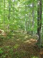
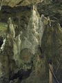
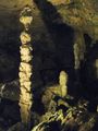
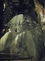
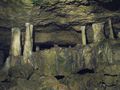
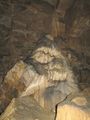
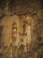
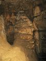
The photographing conditions in the Nebelhöhle cave were ugly, and I didn't bring a tripod. That means, I had to push the amplifiers above their limits, adding huge lots of noise to the pictures. However, I still think they are worth showing. In the Goldloch cave, I dared to use the flash for a few pictures.
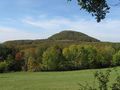
Another Rossberg impression
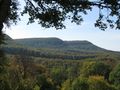
Another Albtrauf impression
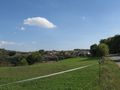
Reaching hash village
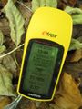
Coordinates reached
The actual hashpoint
View from hashpoint
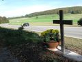
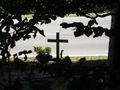
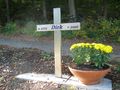
On 2006-12-22, Dirk crashed into this slope, 10 m from the hashpoint.
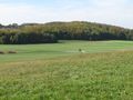
Surroundings of the hash. It's behind the road in the forest.
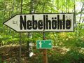
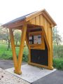
Recycled direction sign
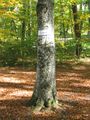
Official peeing tree (the sign says Toiletts, with no arrow or similar, so it should mean the tree itself, shouldn't it?).
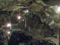
Nebelhöhle cave impressions
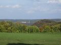
Another landscape impression
Timer for mountainbikers
Goldloch cave impressions
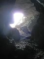
Daylight!


Dirk from Sonnenbühl earned the Darwin Award honorable mention
|