Difference between revisions of "2009-10-03 -35 147"
From Geohashing
imported>Urcher (New page: {{meetup graticule | map=<map lat="-35" lon="147" date="2009-10-03" /> | lat=-35 | lon=147 | date=2009-10-03 | graticule_name=Wagga Wagga, Australia | graticule_link=Wagga Wagga, Australia...) |
imported>Urcher |
||
| Line 24: | Line 24: | ||
| date = 2009-10-03 | | date = 2009-10-03 | ||
| name = Urcher, Bilby and Doomhammer | | name = Urcher, Bilby and Doomhammer | ||
| − | | image = | + | | image = 2009-10-03 -35 147 proof.jpg |
}} | }} | ||
Revision as of 10:59, 15 October 2009
| Sat 3 Oct 2009 in Wagga Wagga, Australia: -35.0763820, 147.3614881 geohashing.info google osm bing/os kml crox |
About
Located in the nature strip of the Olympic Highway, not far from Charles Sturt University
Expeditions
Urcher, Bilby and Doomhammer
Was driving from Melbourne to Junee, did a quick check of the hashpoints along the route before leaving. Glad I checked, I'd be passing within 30m of one on public land anyway. And a virgin graticule to boot.
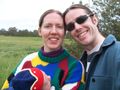
Urcher, Bilby and Doomhammer at the hashpoint

Proof of location

The nearest road sign. Look at the funny names of Australian towns


