Difference between revisions of "2009-12-20 -33 26"
From Geohashing
imported>Barnsza |
imported>Barnsza |
||
| Line 26: | Line 26: | ||
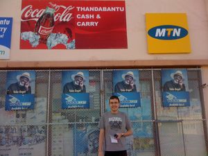
Image:20091220-3326-thandabantubarnsza.jpg | [[User:barnsza|barnsza]] Outside the Cash and Carry | Image:20091220-3326-thandabantubarnsza.jpg | [[User:barnsza|barnsza]] Outside the Cash and Carry | ||
</gallery> | </gallery> | ||
| + | |||
| + | == Ribbons == | ||
| + | {{Virgin graticule | ||
| + | | latitude = -33 | ||
| + | | longitude = 26 | ||
| + | | date = 2009-12-20 | ||
| + | | name = barnsza | ||
| + | | image = 20091220-3326-thandabantu.jpg | ||
| + | }} | ||
[[Category:Expeditions]] | [[Category:Expeditions]] | ||
[[Category:Expeditions with photos]] | [[Category:Expeditions with photos]] | ||
[[Category:Coordinates reached]] | [[Category:Coordinates reached]] | ||
Revision as of 17:09, 20 December 2009
| Sun 20 Dec 2009 in Grahamstown, South Africa: -33.3101225, 26.5346394 geohashing.info google osm bing/os kml crox |
Location
Thandabantu Cash & Carry, Grahamstown, South Africa
Participants
barnsza and a friend.
Expedition
This was the first time a Geohash has actually fallen in Grahamstown itself while I've been watching it. A friend of mine and I walked across there early evening to find that the coordinates are just off the road in a locked building, but we were within 5m of being dead on, so will consider that a find. No other Geohashers were in the area.
Photos
barnsza Outside the Cash and Carry


