Difference between revisions of "2010-01-12 33 -81"
From Geohashing
(→Achievements) |
imported>NWoodruff (→Gallery) |
||
| Line 25: | Line 25: | ||
<gallery perrow="3"> | <gallery perrow="3"> | ||
Image:2010011233-81NW01.JPG | | Image:2010011233-81NW01.JPG | | ||
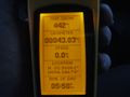
| + | Image:2010011233-81NW41.JPG | 1.25 feet to go. Close enough. | ||
| + | Image:2010011233-81NW42.JPG | I traveled 227 miles to make this geohash at 2:12pm | ||
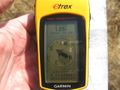
| + | Image:2010011233-81NW43.JPG | Date of the meetup. | ||
| + | Image:2010011233-81NW44.JPG | Looking West standing on the Geohash spot. | ||
| + | Image:2010011233-81NW45.JPG | Looking North standing on the geohash spot. | ||
| + | Image:2010011233-81NW46.JPG | Looking east standing on the Geohash spot. | ||
| + | Image:2010011233-81NW47.JPG | Looking South with a Stupid Grin™. My truck is just over my left shoulder near the corner of the picture. | ||
| + | Image:2010011233-81NW40.JPG | Total round trip picture | ||
</gallery> | </gallery> | ||
Revision as of 18:07, 13 January 2010
| Tue 12 Jan 2010 in Augusta: 33.6392484, -81.2838069 geohashing.info google osm bing/os kml crox |
Graticule
About
In a big open field east of Wagener South Carolina.
Expedition
NWoodruff
Gallery
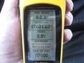
1.25 feet to go. Close enough.
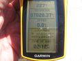
I traveled 227 miles to make this geohash at 2:12pm
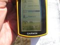
Date of the meetup.
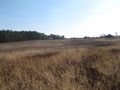
Looking West standing on the Geohash spot.
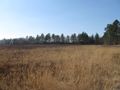
Looking North standing on the geohash spot.
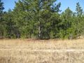
Looking east standing on the Geohash spot.
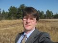
Looking South with a Stupid Grin™. My truck is just over my left shoulder near the corner of the picture.
Total round trip picture


Achievements
NWoodruff earned the Land geohash achievement
|