Difference between revisions of "2010-04-02 34 -108"
From Geohashing
imported>Redaragorn (Created page with '{{meetup graticule | map=<map lat="34" lon="-107" date="2009-11-06" /> | lat=34 | lon=-108 | date=2010-04-02 }} == Location == On the open, rolling grasslands south of the lav…') |
imported>Redaragorn |
||
| Line 32: | Line 32: | ||
Image:2010-04-02 34 -108 - GPS.JPG|GPS coordinates anthill | Image:2010-04-02 34 -108 - GPS.JPG|GPS coordinates anthill | ||
| − | Image:2010-04-02 34 -108 - grin.JPG|Me grinning and son being | + | Image:2010-04-02 34 -108 - grin.JPG|Me grinning and son being cold. |
| − | Image:2010-04-02 34 -108 - grinning boy.JPG| | + | Image:2010-04-02 34 -108 - grinning boy.JPG|The boy shows his smile. |
| − | Image:2010-04-02 34 -108 - landscape.JPG| | + | Image:2010-04-02 34 -108 - landscape.JPG|A patch of blue in a stormy sky. |
</gallery> | </gallery> | ||
| Line 40: | Line 40: | ||
== Achievements == | == Achievements == | ||
| − | {{Virgin graticule | + | {{Virgin graticule | latitude = 34| longitude = -108 | date = 2010-04-02 | name = [[User:Redaragorn|redaragorn]] }} |
[[Category:Expeditions]] | [[Category:Expeditions]] | ||
[[Category:Coordinates reached]] | [[Category:Coordinates reached]] | ||
Revision as of 03:19, 5 April 2010
| Fri 2 Apr 2010 in 34,-108: 34.8064218, -108.1217503 geohashing.info google osm bing/os kml crox |
Location
On the open, rolling grasslands south of the lava flows in the West Malpais Wilderness.
Participants
- redaragorn and 3 yr old son
Plans
Expedition
Track
Track located here.
Pictures
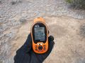
GPS coordinates anthill
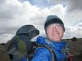
Me grinning and son being cold.
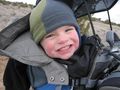
The boy shows his smile.
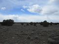
A patch of blue in a stormy sky.


