Difference between revisions of "2010-05-11 45 -123"
From Geohashing
imported>Jiml (Add report info) |
imported>Jiml (Add photos) |
||
| Line 23: | Line 23: | ||
== Photos == | == Photos == | ||
| − | |||
| − | |||
| − | |||
| − | |||
<gallery perrow="4"> | <gallery perrow="4"> | ||
| + | Image:2010-05-11_45_-123-sign.jpg | Not sure about the falls is, but note the dark woods behind | ||
| + | Image:2010-05-11_45_-123-loggingRd.jpg | The road we're on | ||
| + | Image:2010-05-11_45_-123-slash.jpg | The path in to the hashpoint | ||
| + | Image:2010-05-11_45_-123-area2.jpg |What the hashpoint looked like | ||
| + | |||
| + | Image:2010-05-11_45_-123-GPS2.jpg | Proof | ||
| + | Image:2010-05-11_45_-123-GPS1.jpg | Note the elevation | ||
| + | Image:2010-05-11_45_-123-grin.jpg| A geohashing grin | ||
| + | |||
| + | |||
| + | |||
| + | |||
</gallery> | </gallery> | ||
Revision as of 06:27, 7 June 2010
| Tue 11 May 2010 in 45,-123: 45.7537345, -123.4217636 geohashing.info google osm bing/os kml crox |
Location
Near Timber, Oregon, Slightly south of Hwy 26, on a logging road.
Participants
Plans
I decided to go, sent out an email, and created an expedition page. I also printed out the Google Maps page, and figured out the coordinates of the logging road intersections.
Expedition
I made it. More later.
Photos
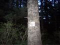
Not sure about the falls is, but note the dark woods behind
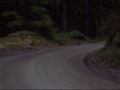
The road we're on
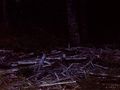
The path in to the hashpoint
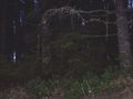
What the hashpoint looked like
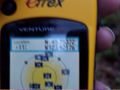
Proof
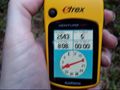
Note the elevation

A geohashing grin


