Difference between revisions of "2010-06-05 35 -81"
imported>NWoodruff |
imported>Rhonda (→Photos: the promised forthcoming photos. Well, only two, but still.) |
||
| Line 24: | Line 24: | ||
== Photos == | == Photos == | ||
| − | |||
| − | |||
| − | |||
| − | |||
<gallery perrow="5"> | <gallery perrow="5"> | ||
| + | Image:2010-06-05 35 -81 Roadside.jpg | Yup, the hashpoint was on the side of a road. | ||
| + | Image:2010-06-05 35 -81 GPS and sophie.jpg | Sadly, I was so intent on getting a clear shot of my GPS screen that I committed poor snapshotting and cut off the top of Sophie's head! | ||
</gallery> | </gallery> | ||
Revision as of 00:25, 8 August 2013
| Sat 5 Jun 2010 in 35,-81: 35.4318804, -81.2300218 geohashing.info google osm bing/os kml crox |
Location
On Gastonia Hwy south of Lincolnton. On the road, according to google maps.
Participants
- Rhonda in the morning, probably early as I'm going to visit somebody that day, farther north.
Plans
Planning on making this a morning hash as I have plans for most of the day, and this point is a bit of a detour from my route between south of Charlotte and my destination.
Expedition
Got to the hash point at 9:30 AM as planned. There was an empty church parking lot about 100m south, so I parked there after driving over the point twice (once northbound, once southbound to get back to the church). I didn't attempt speed racer proof, although I was doing the speed limit as I drove over it the first time; Sophie doesn't know how to work a camera, and I figured driving safely was more important.
I walked to the hash point on the grass beside the road, because there was no paved shoulder. There were at least white shoulder lines painted; I found out later in the day that on most of the country highways, the road just stops where the edge of the lane is. I had to pace over the hash point several times to get a good GPS proof shot. Not sure what the locals thought of me staring down at my jumbo wristwatch and pacing back and forth with a rubber giraffe in my hand, but at least I didn't have to go into the road to get a suitable shot.
After I got back to the car, I tried to do a live update for about 15 minutes, but after I solved the captcha it asked me to copy and paste some long string of gibberish somewhere I couldn't figure out (probably due to the tiny screen). Then I gave up and kept on north, taking the highway that ran across a sizeable lake to get back to 77N because I figured it would be prettier. I managed to not get lost with only handwritten directions copied from google, justifying again my choice to spurn car GPS units!
Photos
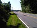
Yup, the hashpoint was on the side of a road.
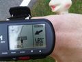
Sadly, I was so intent on getting a clear shot of my GPS screen that I committed poor snapshotting and cut off the top of Sophie's head!

