Difference between revisions of "2010-06-13 51 5"
imported>Antior m (Starting a report page) |
imported>Antior (Yay, report) |
||
| Line 1: | Line 1: | ||
| + | [[Image:2010-06-13-51,5d.jpg|thumb|left]] | ||
| − | |||
| − | |||
| − | |||
| − | |||
| − | |||
| − | |||
{{meetup graticule | {{meetup graticule | ||
| lat=51 | | lat=51 | ||
| Line 12: | Line 7: | ||
}} | }} | ||
| − | |||
__NOTOC__ | __NOTOC__ | ||
== Location == | == Location == | ||
| − | + | Right at the side of a road next to a highway, in the town of Drunen. | |
== Participants == | == Participants == | ||
| − | + | * [[User:Antior|Antior]] | |
| + | * Antior's parents | ||
== Plans == | == Plans == | ||
| − | + | I saw the location was in reach and my parents were planning to do a daytrip anyway, so I asked them if we could stop for a moment at the hashpoint. | |
== Expedition == | == Expedition == | ||
| − | + | We just went there by car and my dad stopped at the closest place possible, about 100m from the hash. They waited for me while I got out with my cam and the GPS device and went to look for the exact spot. First I misinterpreted the direction a bit and ended up in some bushy place behind some place containing car wrecks. Then I went back and found out I had to be at the other side of the road. To find the spot I had to walk back and forth a bit. The GPS device is meant for car navigation and doesn't update itself unless I move fast and far enough, which decreases the actual accuracy. But as far as I can check I passed over the exact spot while walking back and forth. I made some pictures of the surroundings and quickly returned to my parents to continue the rest of our trip. | |
| − | |||
| − | |||
| − | |||
== Photos == | == Photos == | ||
| Line 34: | Line 26: | ||
--> | --> | ||
<gallery perrow="5"> | <gallery perrow="5"> | ||
| + | Image:2010-06-13-51,5f.jpg | The bushy path I went to first | ||
| + | Image:2010-06-13-51,5d.jpg | The car wreck place | ||
| + | Image:2010-06-13-51,5h.jpg | Okay, I found the right place on the other side of the road | ||
| + | Image:2010-06-13-51,5j.jpg | Picture made from the #. with car wreck place in background. | ||
| + | Image:2010-06-13-51,5k.jpg | Same road, looking towards the other end | ||
| + | Image:2010-06-13-51,5i.jpg | There were some factory buildings behind the #. | ||
| + | Image:2010-06-13-51,5m.jpg | Because of the limited accuracy, in principle the hash could've been in that canal, but let's assume not. ;) | ||
| + | |||
</gallery> | </gallery> | ||
== Achievements == | == Achievements == | ||
| − | {{ | + | {{land geohash |
| − | + | | latitude = 51 | |
| + | | longitude = 5 | ||
| + | | date = 2010-06-13 | ||
| + | | name = Antior | ||
| + | }} | ||
| − | + | {{drag-along | |
| − | + | | latitude = 51 | |
| − | + | | longitude = 5 | |
| + | | date = 2010-06-13 | ||
| + | | partner = Antior's parents | ||
| + | | name = Antior | ||
| + | |||
| + | }} | ||
| − | |||
| − | |||
| − | |||
| − | |||
| − | |||
[[Category:Expeditions]] | [[Category:Expeditions]] | ||
| − | |||
[[Category:Expeditions with photos]] | [[Category:Expeditions with photos]] | ||
| − | |||
| − | |||
| − | |||
| − | |||
| − | |||
[[Category:Coordinates reached]] | [[Category:Coordinates reached]] | ||
| − | |||
| − | |||
| − | |||
| − | |||
| − | |||
| − | |||
| − | |||
| − | |||
| − | |||
| − | |||
Revision as of 20:20, 13 June 2010

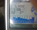
| Sun 13 Jun 2010 in 51,5: 51.6961531, 5.1499792 geohashing.info google osm bing/os kml crox |
Location
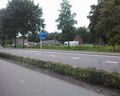
Right at the side of a road next to a highway, in the town of Drunen.
Participants
- Antior
- Antior's parents
Plans
I saw the location was in reach and my parents were planning to do a daytrip anyway, so I asked them if we could stop for a moment at the hashpoint.
Expedition
We just went there by car and my dad stopped at the closest place possible, about 100m from the hash. They waited for me while I got out with my cam and the GPS device and went to look for the exact spot. First I misinterpreted the direction a bit and ended up in some bushy place behind some place containing car wrecks. Then I went back and found out I had to be at the other side of the road. To find the spot I had to walk back and forth a bit. The GPS device is meant for car navigation and doesn't update itself unless I move fast and far enough, which decreases the actual accuracy. But as far as I can check I passed over the exact spot while walking back and forth. I made some pictures of the surroundings and quickly returned to my parents to continue the rest of our trip.
Photos
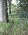
The bushy path I went to first
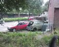
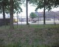
The car wreck place
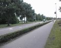
Okay, I found the right place on the other side of the road
Picture made from the #. with car wreck place in background.
Same road, looking towards the other end
There were some factory buildings behind the #.
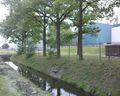
Because of the limited accuracy, in principle the hash could've been in that canal, but let's assume not. ;)


Achievements
Antior earned the Land geohash achievement
|
Antior earned the Drag-along achievement
|