Difference between revisions of "2010-07-10 39 -104"
imported>Ralph (→Expedition) |
imported>Ralph (→Photos) |
||
| Line 19: | Line 19: | ||
Image:Ralph201007103.jpg | View from the hash | Image:Ralph201007103.jpg | View from the hash | ||
Image:Ralph201007104.jpg | The hashpost | Image:Ralph201007104.jpg | The hashpost | ||
| + | Image:Ralph201007106.jpg | Blurry, washed out proof | ||
Image:Ralph201007105.jpg | Runoff to play in equals happy dogs and... | Image:Ralph201007105.jpg | Runoff to play in equals happy dogs and... | ||
Image:Ralph201007101.jpg | a dirty foot. | Image:Ralph201007101.jpg | a dirty foot. | ||
Revision as of 18:45, 10 July 2010
| Sat 10 Jul 2010 in 39,-104: 39.6311590, -104.7338689 geohashing.info google osm bing/os kml crox |
Plans
A short ten miles from home seems like an easy first hash as well as a great place for the kids to enjoy a morning frolic.
Participants
Ralph, Tanna, Hendrix
Expedition
After a 15 minute drive, I stashed my car on the side of the road and Mr. Garmin directed me a quarter mile towards a fencepost in the middle of a large open space. It looked like a large housing development was in the works for the area, but hopefully the field we were in might stick around unpaved and un-housed for a bit since it contained the drainage ditch for the area as well as some power lines. The field across the way had already been set aside for a future bark park. After the dogs tired themselves out, we took a long-cut home in order to grab my first Waffle House in entirely too long down in Parker. Surprisingly enough, the dogs weren't entirely opposed to a slice of bacon for a mid-morning snack.
Photos
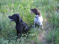
Hendrix and Tanna at the hash
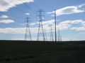
View from the hash
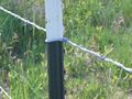
The hashpost
Blurry, washed out proof
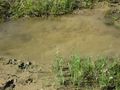
Runoff to play in equals happy dogs and...
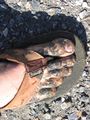
a dirty foot.


Achievements
Ralph earned the Land geohash achievement
|