Difference between revisions of "2010-08-10 53 9"
imported>Jiml m (Fix incorrect brackets) |
imported>Hermann (finally wrote the expedition log) |
||
| Line 1: | Line 1: | ||
| − | |||
| − | |||
| − | |||
| − | |||
| − | |||
| − | |||
| − | |||
| − | |||
| − | |||
{{meetup graticule | {{meetup graticule | ||
| lat=53 | | lat=53 | ||
| Line 15: | Line 6: | ||
| graticule_link=Hamburg, Germany | | graticule_link=Hamburg, Germany | ||
}} | }} | ||
| − | |||
__NOTOC__ | __NOTOC__ | ||
| Line 22: | Line 12: | ||
== Participants == | == Participants == | ||
| − | + | [[User:Hermann|Hermann]] and two friends of his | |
| − | |||
| − | |||
| − | |||
| − | |||
== Expedition == | == Expedition == | ||
| − | + | === Hermann === | |
| − | + | I was able to talk two of my friends into coming with me by keeping quiet about going geohashing. One of them dislikes the Idea of geohashing in general and would not have come. Instead I suggested going on a normal bike trip. When we came nearer to the hash it dawned on them, what I was up to and refused to appear on any photo taken. It still was funny having them with me as one of them pointed directly at the sun proclaiming that direction was north and we had to persuade him that was impossible on the northern hemisphere. We found out the hash was in a part of the forest which dense scrubs and the owner had raised a heap of rotten wood all along the way. I decided not to force my way in there through the hash. | |
| + | == Photos == | ||
| + | <gallery perrow="4"> | ||
| + | File:Hermann_Geohash_2010-08-10_53_9_P8100169.jpg|Hermann near the hash | ||
| + | File:Hermann_Geohash_2010-08-10_53_9_P8100170.jpg|wall of despair | ||
| + | </gallery> | ||
| − | [[Category:Expedition | + | [[Category:Expedition]] |
| + | [[Category:Expeditions with photos]] | ||
| + | [[Category:Coordinates not reached]] | ||
| + | [[Category:Not reached - No public access]] | ||
Revision as of 16:32, 29 January 2011
| Tue 10 Aug 2010 in Hamburg, Germany: 53.6189153, 9.7722010 geohashing.info google osm bing/os kml crox |
Location
In a wooded area southwest of Pinneberg-Waldenau, just across the Schleswig-Holstein/Hamburg border from "Klövensteen" Forest.
Participants
Hermann and two friends of his
Expedition
Hermann
I was able to talk two of my friends into coming with me by keeping quiet about going geohashing. One of them dislikes the Idea of geohashing in general and would not have come. Instead I suggested going on a normal bike trip. When we came nearer to the hash it dawned on them, what I was up to and refused to appear on any photo taken. It still was funny having them with me as one of them pointed directly at the sun proclaiming that direction was north and we had to persuade him that was impossible on the northern hemisphere. We found out the hash was in a part of the forest which dense scrubs and the owner had raised a heap of rotten wood all along the way. I decided not to force my way in there through the hash.
Photos
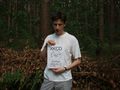
Hermann near the hash
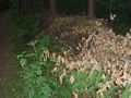
wall of despair

