Difference between revisions of "2010-08-29 42 -89"
imported>Bassoon (Created page with '{{subst:Expedition |lat = 42 |lon = -89 |date = 2010-08-29 }}') |
imported>Bassoon |
||
| Line 1: | Line 1: | ||
| − | |||
| − | |||
| − | |||
| − | |||
| − | |||
| − | |||
| − | |||
| − | |||
| − | |||
| − | |||
{{meetup graticule | {{meetup graticule | ||
| lat=42 | | lat=42 | ||
| Line 15: | Line 5: | ||
}} | }} | ||
| − | |||
| − | |||
== Location == | == Location == | ||
| − | + | In a thicket of dense, low-lying underbrush at the side of a road near Stoughton, Wisconsin. | |
== Participants == | == Participants == | ||
| − | + | * [[User:Bassoon|Bassoon]] | |
| + | * [[User:Dedehawk|Dedehawk]] | ||
| + | * [[User:Kuderererer|Kuderererer]] | ||
== Plans == | == Plans == | ||
| − | + | From what the map said, it looked like we could just show up, tromp through what would hopefully be a stand of trees at the side of the road, and then leave. | |
== Expedition == | == Expedition == | ||
| − | + | We left from Dedehawk's house around 4. Like most hashes in the western graticules, we headed out west on I-94. Eventually, we took a random exit that led us on small county highways to the hash. This is why Bassoon loves his GPS. Rather than taking the freeway the whole way, his GPS will randomly decide to get off on random exits and make him follow back country roads until he miraculously arrives at his doorstep. Talk about an adventure machine! | |
| + | |||
| + | Anyhow, after getting off of I-94, we discovered how freaking beautiful central Wisconsin is. We'd all seen northern Wisconsin many times before, because that's where you go when you go 'up north', oddly enough. Central Wisconsin only has Madison to pull people towards it, but the landscape around Madison is different from the true central Wisconsin that we were in. So it was neat to see rolling hills and sweeping valleys when we only normally see flat plains or rocky dells. | ||
| + | |||
| + | We finally arrived at the hash after driving around, gawking out the window. After we got out, we realized that this was not a stand of trees. Not by a long shot. | ||
| + | |||
| + | No, the supposed stand of trees was actually a thicket of sumac, saplings, and some suspicious-looking plants that were starting to turn a deep maroon color for the fall. What to do now? | ||
| + | |||
| + | Well, we weren't gonna let a few bushes stop us from getting to the hash! Dedehawk stood back by the road while Kuderererer and Bassoon surveyed the thicket, looking for the best possible entrance. A few times a car drove by and Dedehawk yelled duck, so everyone dropped down and hid until the offenders drove by. After a few false starts, we picked a pre-made pathway that we found in front of the thicket. It was probably an animal trail. | ||
| + | |||
| + | Bassoon and Kuderererer went through the dense, low-lying underbrush, pushing and shoving and tromping plants out of the way. Several times, the plants pushed, shoved, and tromped back. Sometimes, the plants even bit back. But we eventually worked our way into the center of the thicket... | ||
| + | |||
| + | ...where the mosquitoes were the worst. As we stood there being eaten alive, Bassoon stared at the GPS, which fluctuated wildly between one foot away and three feet away. Eventually, we just decided to stop and take a picture before the GPS started acting even weirder. We called Dedehawk into the thicket. | ||
| + | |||
| + | "Where the hell are you guys? I can't even see you!" | ||
| + | |||
| + | Oops. So we told her to follow the sound of our voice. She wondered how the hell we managed to get in there. Something hit her in the face. When she finally reached us, we tried to figure out how to take our group photo. In the end, we decided on the old "hold the camera and try to get everyone in" trick. After we did that, we ran as fast as we could out of the thicket and back to the car. Everything was itchy! But not because of poison plants, but because of all of the mosquito bites. | ||
| − | + | We looked for somewhere to eat, and eventually settled on a Culver's in Stoughton. After that, we headed back home on I-94 and complained about how we were covered in little bits of wood. | |
| − | |||
== Photos == | == Photos == | ||
| − | |||
| − | |||
| − | |||
<gallery perrow="5"> | <gallery perrow="5"> | ||
| + | Image:2010-08-29 42 -89 kudersoon.png | Kuderer looks on while Bassoon negotiates with his GPS. | ||
| + | Image:2010-08-29_42_-89_trailblazing.png | Blazing a new, ineffective trail. | ||
| + | Image:2010-08-29_42_-89_leaves.png | This is why Dedehawk couldn't see us. | ||
| + | Image:2010-08-29_42_-89_victory.png | We braved the plants and bugs and the ticks for this! | ||
| + | Image:2010-08-29_42_-89_groupshot.png | Here we are, in our disheveled, trapped-in-a-thickety glory! | ||
</gallery> | </gallery> | ||
== Achievements == | == Achievements == | ||
{{#vardefine:ribbonwidth|800px}} | {{#vardefine:ribbonwidth|800px}} | ||
| − | + | {{land geohash | |
| − | + | | latitude = 42 | |
| − | + | | longitude = -89 | |
| − | + | | date = 2010-08-29 | |
| − | + | | name = Bassoon, Dedehawk, and Kuderererer | |
| − | + | | image = 2010-08-29_42_-89_trailblazing.png | |
| − | + | }} | |
| − | + | {{Minesweeper geohash | |
| − | + | | graticule = Fond du Lac, Wisconsin | |
| − | + | | ranknumber = 5 | |
| − | + | | n = true if graticule to the north has been hashed (optional) | |
| + | | s = true if graticule to the south has been hashed (optional) | ||
| + | | sw = true if graticule to the southwest has been hashed (optional) | ||
| + | | w = true if graticule to the west has been hashed (optional) | ||
| + | | nw = true if graticule to the northwest has been hashed (optional) | ||
| + | | name = Bassoon and Dedehawk | ||
| + | }} | ||
| + | {{Minesweeper geohash | ||
| + | | graticule = full name of the centre graticule in your grid (required) | ||
| + | | ranknumber = 3 | ||
| + | | sw = true if graticule to the southwest has been hashed (optional) | ||
| + | | w = true if graticule to the west has been hashed (optional) | ||
| + | | nw = true if graticule to the northwest has been hashed (optional) | ||
| + | | name = Kuderererer | ||
| + | }} | ||
| − | |||
[[Category:Expeditions]] | [[Category:Expeditions]] | ||
| − | |||
[[Category:Expeditions with photos]] | [[Category:Expeditions with photos]] | ||
| − | |||
| − | |||
| − | |||
| − | |||
| − | |||
[[Category:Coordinates reached]] | [[Category:Coordinates reached]] | ||
| − | |||
| − | |||
| − | |||
| − | |||
| − | |||
| − | |||
| − | |||
| − | |||
| − | |||
| − | |||
Revision as of 18:12, 30 August 2010
| Sun 29 Aug 2010 in 42,-89: 42.9542821, -89.1512477 geohashing.info google osm bing/os kml crox |
Location
In a thicket of dense, low-lying underbrush at the side of a road near Stoughton, Wisconsin.
Participants
Plans
From what the map said, it looked like we could just show up, tromp through what would hopefully be a stand of trees at the side of the road, and then leave.
Expedition
We left from Dedehawk's house around 4. Like most hashes in the western graticules, we headed out west on I-94. Eventually, we took a random exit that led us on small county highways to the hash. This is why Bassoon loves his GPS. Rather than taking the freeway the whole way, his GPS will randomly decide to get off on random exits and make him follow back country roads until he miraculously arrives at his doorstep. Talk about an adventure machine!
Anyhow, after getting off of I-94, we discovered how freaking beautiful central Wisconsin is. We'd all seen northern Wisconsin many times before, because that's where you go when you go 'up north', oddly enough. Central Wisconsin only has Madison to pull people towards it, but the landscape around Madison is different from the true central Wisconsin that we were in. So it was neat to see rolling hills and sweeping valleys when we only normally see flat plains or rocky dells.
We finally arrived at the hash after driving around, gawking out the window. After we got out, we realized that this was not a stand of trees. Not by a long shot.
No, the supposed stand of trees was actually a thicket of sumac, saplings, and some suspicious-looking plants that were starting to turn a deep maroon color for the fall. What to do now?
Well, we weren't gonna let a few bushes stop us from getting to the hash! Dedehawk stood back by the road while Kuderererer and Bassoon surveyed the thicket, looking for the best possible entrance. A few times a car drove by and Dedehawk yelled duck, so everyone dropped down and hid until the offenders drove by. After a few false starts, we picked a pre-made pathway that we found in front of the thicket. It was probably an animal trail.
Bassoon and Kuderererer went through the dense, low-lying underbrush, pushing and shoving and tromping plants out of the way. Several times, the plants pushed, shoved, and tromped back. Sometimes, the plants even bit back. But we eventually worked our way into the center of the thicket...
...where the mosquitoes were the worst. As we stood there being eaten alive, Bassoon stared at the GPS, which fluctuated wildly between one foot away and three feet away. Eventually, we just decided to stop and take a picture before the GPS started acting even weirder. We called Dedehawk into the thicket.
"Where the hell are you guys? I can't even see you!"
Oops. So we told her to follow the sound of our voice. She wondered how the hell we managed to get in there. Something hit her in the face. When she finally reached us, we tried to figure out how to take our group photo. In the end, we decided on the old "hold the camera and try to get everyone in" trick. After we did that, we ran as fast as we could out of the thicket and back to the car. Everything was itchy! But not because of poison plants, but because of all of the mosquito bites.
We looked for somewhere to eat, and eventually settled on a Culver's in Stoughton. After that, we headed back home on I-94 and complained about how we were covered in little bits of wood.
Photos
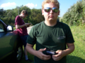
Kuderer looks on while Bassoon negotiates with his GPS.
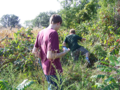
Blazing a new, ineffective trail.
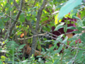
This is why Dedehawk couldn't see us.
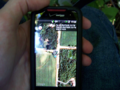
We braved the plants and bugs and the ticks for this!

Here we are, in our disheveled, trapped-in-a-thickety glory!


Achievements
Bassoon, Dedehawk, and Kuderererer earned the Land geohash achievement
|
Bassoon and Dedehawk achieved level 5 of the Minesweeper Geohash achievement
|
Kuderererer achieved level 3 of the Minesweeper Geohash achievement
|