Difference between revisions of "2010-09-01 45 9"
imported>Tankmiche (→Expedition: forty) |
imported>Tankmiche (→Photos) |
||
| Line 29: | Line 29: | ||
Image:01092010724.jpg|One of the beautiful places I've seen. I wish I had time to go to the source of this river! | Image:01092010724.jpg|One of the beautiful places I've seen. I wish I had time to go to the source of this river! | ||
Image:01092010722.jpg|The mountains around the river | Image:01092010722.jpg|The mountains around the river | ||
| − | Image:01092010729.jpg|The road in the water. Maybe you can see the waves of my foot | + | Image:01092010729.jpg|The road in the water. Maybe you can see the waves of my foot when I almost fell... |
Image:01092010728.jpg|The gate blocking my path | Image:01092010728.jpg|The gate blocking my path | ||
</gallery> | </gallery> | ||
Revision as of 08:47, 2 September 2010
| Wed 1 Sep 2010 in 45,9: 45.8186082, 9.8009115 geohashing.info google osm bing/os kml crox |
Location
Val Vertova, Bergamo, Italy
Participants
Expedition
The location fell within the nine centicules surrounding my area, so I could pick up the bike and start riding. I've known for some years now the road to Vertova, since there's a bicycle path nearby, there the first forty minutes were relatively boring. I had planned to find the right road without a GPS, then proceed only for the last kilometers with the help of my Nokia's Ovi Maps. So I was able to get lost even on the known route.
Anyway, thanks to some people pointing me to the right direction I was able to turn into the right street, which started to narrow and eventually became somewhat steep, right after a funny sign "Warning: this road hasn't been tested". At that point I started Ovi Maps, which always picks stellite signal after three or four minutes even in optimal conditions. But I had to stop, as it was taking more than ten minutes and I wasn't even sure to be on the right road.
100 meters in front of me I saw a map of the Val Vertova, but no road matched what my Nokia or Google Maps displayed, it was a footpath map. Desperate I began to think of heading back home, when my Nokia got the signal! I was just 1.1km away from the objective. As I approached the spot I knew it was going to be very difficult to reach it, as my road was turning right and the coordinates probably were on the other side of the river.
Nevertheless I crossed the river on a path in the water (car only, I guess), almost falling from the bike in the process. I eventually found a gate, just 40 meters away from the right coordinates, with no sign of human presence anywhere. My shoes are completely wet, but it was worth it - Val Vertova is an amazing place after all.
Total trip time: 3 hours 40 minutes.
Photos
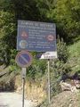
"Strada non collaudata", not-tested road
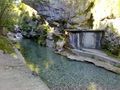
One of the beautiful places I've seen. I wish I had time to go to the source of this river!
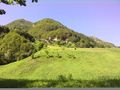
The mountains around the river
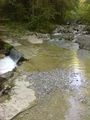
The road in the water. Maybe you can see the waves of my foot when I almost fell...
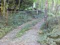
The gate blocking my path


