Difference between revisions of "2010-09-09 39 -108"
From Geohashing
imported>Messyhair42 |
imported>Messyhair42 (→Photos) |
||
| Line 29: | Line 29: | ||
<gallery perrow="5"> | <gallery perrow="5"> | ||
| − | Image:2010-09-09 39 -108 landscape|the landscape of the hashpoint | + | Image:2010-09-09 39 -108 landscape.JPG|the landscape of the hashpoint |
</gallery> | </gallery> | ||
<gallery perrow="5"> | <gallery perrow="5"> | ||
| − | Image:User Messyhair42 at 2010-09-09 39 -108|Me, with xkcd shirt, at the hashpoint | + | Image:User Messyhair42 at 2010-09-09 39 -108.JPG|Me, with xkcd shirt, at the hashpoint |
</gallery> | </gallery> | ||
<gallery perrow="5"> | <gallery perrow="5"> | ||
| − | Image:Reciept admit one CNM 2010-09-09 39 -108|reciept for entrance to the Colorado National Monument $7 | + | Image:Reciept admit one CNM 2010-09-09 39 -108.JPG|reciept for entrance to the Colorado National Monument $7 |
</gallery> | </gallery> | ||
Revision as of 03:40, 15 September 2010
| Thu 9 Sep 2010 in 39,-108: 39.0347876, -108.6279388 geohashing.info google osm bing/os kml crox |
Location
on the side of a dirt road within the Colorado National Monument
Participants
Plans
Get to the Hash point, no matter what
Expedition
Took a morning drive to the Colorado National Monument after I realized the Hash Point was so close. Paid a $7 fee for Vehicle Entrance (Admit One Achievement). Had to park and hop a road block to reach the hash point ~250M walking
Photos
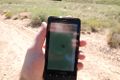
coordinates displayed


the landscape of the hashpoint


Me, with xkcd shirt, at the hashpoint

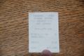
reciept for entrance to the Colorado National Monument $7

Achievements

User:Messyhair42 earned the Admit One Achievement
by paying $7 to access the (39, -108) geohash at Colorado National Monument on 2010-09-09.