Difference between revisions of "2011-01-12 50 6"
imported>NeThuS m (→Photos) |
imported>Mampfred m (cleanup) |
||
| Line 1: | Line 1: | ||
| − | |||
| − | |||
| − | |||
| − | |||
| − | |||
| − | |||
| − | |||
| − | |||
| − | |||
{{meetup graticule | {{meetup graticule | ||
| lat=50 | | lat=50 | ||
| Line 14: | Line 5: | ||
}} | }} | ||
| − | |||
__NOTOC__ | __NOTOC__ | ||
== Location == | == Location == | ||
| − | |||
In a forest near Viesalm, Not too far from my route of Willstät - Leuven | In a forest near Viesalm, Not too far from my route of Willstät - Leuven | ||
| Line 32: | Line 21: | ||
I think this was the 2nd time I took this route back home, and just like the previous time the weather was bad: fog and rain at the same time. But no traffic at all. | I think this was the 2nd time I took this route back home, and just like the previous time the weather was bad: fog and rain at the same time. But no traffic at all. | ||
| − | 5 km | + | 5 km after exiting the highway I drove my car 5 meter into a small forest-road some 350 meters of the hash. I changed clothes and shoes, grabbed my headlamp and GPS, and wandered off in the complete dark, only surrounded by the sound of rain falling on and dropping of the trees. it was too wet to take the SLR along, and to dark to take pictures with my cellphone, but I tried nevertheless. |
== Tracklog == | == Tracklog == | ||
| Line 38: | Line 27: | ||
== Photos == | == Photos == | ||
| − | |||
| − | |||
| − | |||
<gallery perrow="5"> | <gallery perrow="5"> | ||
Image:2011-01-12_50_6--stupidGrin.JPG | Stupid Grin | Image:2011-01-12_50_6--stupidGrin.JPG | Stupid Grin | ||
| Line 55: | Line 41: | ||
| name = [[User:NeThuS|NeThuS]] | | name = [[User:NeThuS|NeThuS]] | ||
}} | }} | ||
| − | |||
| − | |||
| − | |||
| − | |||
| − | |||
[[Category:Expeditions]] | [[Category:Expeditions]] | ||
| − | |||
[[Category:Coordinates reached]] | [[Category:Coordinates reached]] | ||
| + | [[Category:Expeditions with photos]] | ||
Revision as of 11:32, 16 January 2011
| Wed 12 Jan 2011 in 50,6: 50.3154298, 6.0136620 geohashing.info google osm bing/os kml crox |
Location
In a forest near Viesalm, Not too far from my route of Willstät - Leuven
Participants
Plans
pull over at the right spot / picture / leave
Expedition
Instead of taking the usual way from Willstät to Leuven via Strasbourg - Metz - Luxembourg (and thus crossing the German-French, French-Luxembourg and Luxembourg-Belgian borders) I had to relocate the route over Saarbrücken, E422, E42 - Luik/liège/Lüttich, so I crossed the French/German and German/Belgian borders instead. Finally a border geohash for me, and strangely enough for a hash in my home country.
An extra advantage of this detour was that it led me to Germany not via a highway, but via some small roads and towns instead. Complete with restaurants and everything! The border itself was not indicated, but when I passed the 2nd restaurant named 'La Frontiere' I knew I must had passed it and celebrated my boarder geohash with a pizza frontiere for dinner. I think this was the 2nd time I took this route back home, and just like the previous time the weather was bad: fog and rain at the same time. But no traffic at all.
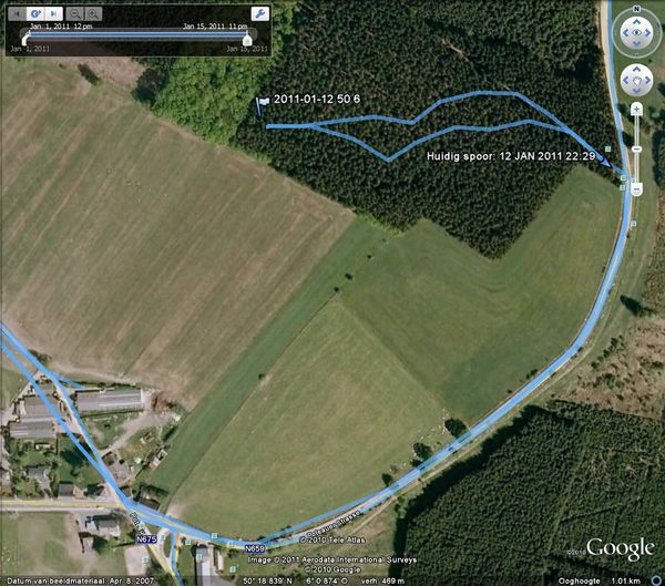
5 km after exiting the highway I drove my car 5 meter into a small forest-road some 350 meters of the hash. I changed clothes and shoes, grabbed my headlamp and GPS, and wandered off in the complete dark, only surrounded by the sound of rain falling on and dropping of the trees. it was too wet to take the SLR along, and to dark to take pictures with my cellphone, but I tried nevertheless.
Tracklog
Photos
Achievements
NeThuS earned the Border geohash achievement
|

