Difference between revisions of "2011-01-25 52 5"
imported>CO2 (Changing stuff to new username) |
imported>FippeBot m (Location) |
||
| Line 41: | Line 41: | ||
[[Category:Expedition without GPS]] | [[Category:Expedition without GPS]] | ||
[[Category:Coordinates reached]] | [[Category:Coordinates reached]] | ||
| + | {{location|NL|UT}} | ||
Latest revision as of 05:20, 9 August 2019
| Have you seen our geohashing marker? We'd love to hear from you! Click here to say "hi" and tell us what you've seen!
Curious about what geohashing is? Read more! |  |
| Tue 25 Jan 2011 in 52,5: 52.0835668, 5.2646827 geohashing.info google osm bing/os kml crox |
Location
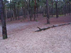
In a foresty part of Zeist. Very close to the buildings of a Scouting group.
Participants
Plans
Well, it's close by and seems reachable. Also, it's in a foresty area. So I'll just go there.
Expedition
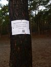
After doing another errand, I was already on my bike, and I already brought my stuff, so I decided to not stop by my home, but just go to the hash right away. It was a bit windy, coldish and rainy, but after a bit the sun started shining. When I got to forest path I parked my bike and walked the last bit. As it turned out the location was in the little field exactly opposite to the Scouting Buildings. I tried to find the exact location (without GPS) and I think I managed, though the terrain had changed a little bit since the Google photo. I certainly got within the uncertainty range. I attached the marker to the lone tree near the hash in such a way that people walking over the forest path or people at the Scouting will see it. I wonder if I get any reactions from them here...


