Difference between revisions of "2011-07-03 39 -76"
From Geohashing
imported>1000miles1stStep (→Achievements) |
imported>Jiml m (Fix result codes, removed unneeded fraction) |
||
| Line 18: | Line 18: | ||
}} | }} | ||
| − | + | ||
__NOTOC__ | __NOTOC__ | ||
== Location == | == Location == | ||
| Line 24: | Line 24: | ||
== Participants == | == Participants == | ||
| − | 1000miles1stStep | + | * [[User:1000miles1stStep1000miles1stStep|1000miles1stStep]] |
== Plans == | == Plans == | ||
| Line 42: | Line 42: | ||
== Photos == | == Photos == | ||
| − | + | ||
| − | |||
| − | |||
<gallery perrow="5"> | <gallery perrow="5"> | ||
Image:IMAG0430.jpg | The magic intersection | Image:IMAG0430.jpg | The magic intersection | ||
| Line 52: | Line 50: | ||
== Achievements == | == Achievements == | ||
{{#vardefine:ribbonwidth|800px}} | {{#vardefine:ribbonwidth|800px}} | ||
| − | |||
{{land geohash | {{land geohash | ||
| − | | latitude = 39 | + | | latitude = 39 |
| − | | longitude = -76 | + | | longitude = -76 |
| date = 2011-07-03 | | date = 2011-07-03 | ||
| name = 1000miles1stStep | | name = 1000miles1stStep | ||
| Line 67: | Line 64: | ||
{{A Tale of Two Hashes challenge | {{A Tale of Two Hashes challenge | ||
| − | | latitude = 39 | + | | latitude = 39 |
| − | | longitude = -76 | + | | longitude = -76 |
| date = 2011-07-03 | | date = 2011-07-03 | ||
| name = 1000miles1stStep | | name = 1000miles1stStep | ||
| Line 77: | Line 74: | ||
| − | |||
| − | |||
| − | |||
| − | |||
| − | |||
| − | |||
| − | |||
| − | |||
| − | |||
[[Category:Expeditions]] | [[Category:Expeditions]] | ||
| − | |||
[[Category:Expeditions with photos]] | [[Category:Expeditions with photos]] | ||
| − | |||
| − | |||
| − | |||
| − | |||
| − | |||
[[Category:Coordinates reached]] | [[Category:Coordinates reached]] | ||
| − | |||
| − | |||
| − | |||
| − | |||
| − | |||
| − | |||
| − | |||
| − | |||
| − | |||
| − | |||
Revision as of 21:17, 4 July 2011

| Sun 3 Jul 2011 in 39,-76: 39.1440572, -76.5689717 geohashing.info google osm bing/os kml crox |
Location
Freetown, MD
Participants
Plans
Expedition
Route: B/W Parkway to MD Rt. 100 East to Mountain Rd. to Freetown Rd.
Mission accomplished at 7:08 PM. Hash point was within a few meters of the street sign for the intersection of Solley Rd. and Freetown Rd.
Weather was thunderstormy.
Tracklog
Photos
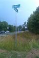
The magic intersection
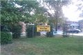
Not sure who Hanz is, and not sure I want a massage from him!

Achievements
1000miles1stStep earned the Land geohash achievement
|
1000miles1stStep issued a challenge for the Tale of Two Hashes achievement
|