Difference between revisions of "2011-07-20 52 1"
From Geohashing
imported>Sourcerer ([live picture] Corn. [http://www.openstreetmap.org/?lat=52.475064396858215&lon=1.4940977096557617&zoom=16&layers=B000FTF @52.4751,1.4941]) |
imported>Jiml m (Add result codes - best guess, though) |
||
| Line 1: | Line 1: | ||
| − | |||
<!-- If you did not specify these parameters in the template, please substitute appropriate values for IMAGE, LAT, LON, and DATE (YYYY-MM-DD format) | <!-- If you did not specify these parameters in the template, please substitute appropriate values for IMAGE, LAT, LON, and DATE (YYYY-MM-DD format) | ||
| Line 15: | Line 14: | ||
}} | }} | ||
| − | |||
__NOTOC__ | __NOTOC__ | ||
== Location == | == Location == | ||
| − | + | A sweet corn field in the UK | |
== Participants == | == Participants == | ||
| − | + | ||
| + | * [[User:Sourcerer|Sourcerer]] | ||
== Plans == | == Plans == | ||
<!-- what were the original plans --> | <!-- what were the original plans --> | ||
| + | |||
| + | Unknown | ||
== Expedition == | == Expedition == | ||
| Line 52: | Line 53: | ||
[[Category:New report]] | [[Category:New report]] | ||
| − | + | [[Category:Expeditions]] | |
| − | + | [[Category:Expeditions with photos]] | |
| − | [[Category: | + | [[Category:Coordinates not reached]] |
| − | - | + | [[Category:Not reached - No public access]] |
| + | |||
<!-- An actual expedition: | <!-- An actual expedition: | ||
Revision as of 02:11, 21 July 2011
| Wed 20 Jul 2011 in 52,1: 52.4747509, 1.4949577 geohashing.info google osm bing/os kml crox |
Location
A sweet corn field in the UK
Participants
Plans
Unknown
Expedition
- 70 meters to the hash but tall sweet corn is blocking access. -- Sourcerer @52.4751,1.4941 19:22, 20 July 2011 (GMT+01:00)
Tracklog
Photos
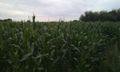
Corn. @52.4751,1.4941

Achievements