Difference between revisions of "2011-08-06 44 -122"
imported>Michael5000 m (→Photos) |
imported>Michael5000 m (→Photos) |
||
| Line 37: | Line 37: | ||
<gallery perrow="5"> | <gallery perrow="5"> | ||
| − | File:2011-08-06 44 -122 landscape.JPG | + | File:2011-08-06 44 -122 landscape.JPG|Foothills of the Cascades |
| − | File:2011-08-06 44 -122 two roads.JPG | + | File:2011-08-06 44 -122 two roads.JPG|Two roads diverged... |
| − | File:2011-08-06 44 -122 road.JPG | + | File:2011-08-06 44 -122 road.JPG|...and I -- I took the one less traveled by |
| − | File:2011-08-06 44 -122 gates.JPG | + | File:2011-08-06 44 -122 gates.JPG|which got me to this gate... |
| − | File:2011-08-06 44 -122 victory.JPG | + | File:2011-08-06 44 -122 victory.JPG|Expedition Success! |
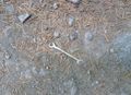
| − | File:2011-08-06 44 -122 view.JPG | + | File:2011-08-06 44 -122 view.JPG|What the hashpoint looks like. |
| − | File:2011-08-06 44 -122 trees.JPG | + | File:2011-08-06 44 -122 trees.JPG|Looking up at trees from the road. |
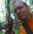
| − | File:2011-08-06 44 -122 bear.JPG | + | File:2011-08-06 44 -122 bear.JPG|Traditional hashscot photo. |
| − | File:2011-08-06 44 -122 wrenches.JPG | + | File:2011-08-06 44 -122 wrenches.JPG|If I had been really needing a 7mm wrench, this would have been incredible! |
</gallery> | </gallery> | ||
Revision as of 01:26, 7 August 2011
| Sat 6 Aug 2011 in 44,-122: 44.9349782, -122.4725153 geohashing.info google osm bing/os kml crox |
Location
In the woods 18 road miles south of Mollala.
Participants
Expedition
In the morning, I ran ten miles. That's not material to the Expedition, I'm just boasting.
After drying off, I waffled about whether I wanted to spend a Saturday afternoon driving a long ways to get to a random point in the woods. When I consulted with Mrs.5000, it emerged that not only had I never attempted the Springfield graticule myself, but that -- startlingly -- it has only one documented expedition to its name, and that in early 2009. That settled things.
An hour or so of driving got me to the forested area of the Cascade foothills where the hashpoint was located. Navigation got increasingly difficult as I got further into the woods, as is usually the case, and a first foray down increasingly primitive forest roads got me no closer than a half mile across obviously rugged terrain. Happily, I was able to backtrack to an inconspicuous side route, and taking the road less traveled by I was able to get to within 2/3 mile -- but with a good track heading in the right direction -- before I decided to park and hike in rather than risk the tires.
At this point, I was startled to see not one but two other vehicles on the road. "OMG Geohashers!" I thought, irrationally. And indeed, they turned out to be people working some sort of small-scale logging operation. "Just out hiking?" asked a bemused young man. "Yep," I replied. About 1/2 mile from the point, I turned off onto a yet more obscure path, past a gate, and up a very steep slope. It was a fairly rugged uphill trek for someone who felt he had already had his exercise for the day, but it did bring me to within 100 feet of the hashpoint, which was then just a quick bushwhack in through the woods. I planted a stick with my calling card -- literally -- against the infinitesimal chance that somebody else also decided to take a swing at the Springfield graticule today. And then I started home.
Photos
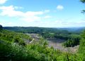
Foothills of the Cascades
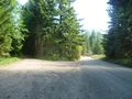
Two roads diverged...
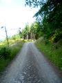
...and I -- I took the one less traveled by
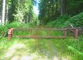
which got me to this gate...
Expedition Success!
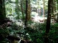
What the hashpoint looks like.
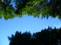
Looking up at trees from the road.
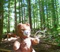
Traditional hashscot photo.
If I had been really needing a 7mm wrench, this would have been incredible!


