Difference between revisions of "2011-09-18 50 8"
From Geohashing
imported>QuarterCacher ([live] Coordinates reached) |
imported>Mampfred |
||
| Line 1: | Line 1: | ||
| − | |||
| − | |||
| − | |||
| − | |||
| − | |||
| − | |||
| − | |||
| − | |||
| − | |||
| − | |||
{{meetup graticule | {{meetup graticule | ||
| lat=50 | | lat=50 | ||
| Line 15: | Line 5: | ||
}} | }} | ||
| − | |||
__NOTOC__ | __NOTOC__ | ||
== Location == | == Location == | ||
| − | + | On a field near Sulzbach. | |
== Participants == | == Participants == | ||
| − | + | *[[User:Mampfred|Mampfred]] | |
| + | *[[User:QuarterCacher|QuarterCacher]] | ||
== Plans == | == Plans == | ||
| − | + | Go there late after work. | |
== Expedition == | == Expedition == | ||
| − | + | Mampfred picked up QuarterCacher and they drove for about 25 minutes. Left the car about 1 km from the hash and walked the rest of the way. Easy hash :) | |
| + | On the way back, we did a couple of caches for good measure (no collision though): | ||
| + | * [http://coord.info/GC2MFTB GC2MFTB] | ||
| + | * [http://coord.info/GC2WWPJ GC2WWPJ] | ||
| + | * [http://coord.info/GCM3N4 GCM3N4] | ||
| − | |||
== Tracklog == | == Tracklog == | ||
| − | + | See [http://www.everytrail.com/view_trip.php?trip_id=1295438 here]. | |
== Photos == | == Photos == | ||
| − | |||
| − | |||
| − | |||
<gallery perrow="5"> | <gallery perrow="5"> | ||
| + | Image:2011-09-18_50_8_parking.jpg | Left the car ... | ||
| + | Image:2011-09-18_50_8_view.jpg | ... and continued on foot. | ||
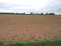
| + | Image:2011-09-18_50_8_sulzbach_agriculture.jpg | The Sulzbach agriculture. Lecture on the way. | ||
| + | Image:2011-09-18_50_8_bird_watch.jpg | Didn't see one of them. | ||
| + | Image:2011-09-18_50_8_nandu_speed_limit.jpg | What now? | ||
| + | Image:2011-09-18_50_8_coordinates.jpg | Coordinates ... | ||
| + | Image:2011-09-18_50_8_reached.jpg | ... reached. | ||
| + | Image:2011-09-18_50_8_hash.jpg | Look at the hash. | ||
| + | Image:2011-09-18_50_8_stupid_grin.jpg | Stupid grin. | ||
| + | Image:2011-09-18_50_8_horse_wisperer.jpg | QuarterCacher communicating. Not sure who's getting the tongue ... | ||
</gallery> | </gallery> | ||
== Achievements == | == Achievements == | ||
{{#vardefine:ribbonwidth|800px}} | {{#vardefine:ribbonwidth|800px}} | ||
| − | + | {{Land geohash | |
| + | | latitude = 50 | ||
| + | | longitude = 8 | ||
| + | | date = 2011-09-18 | ||
| + | | name = Mampfred and QuarterCacher | ||
| + | }} | ||
| − | |||
| − | |||
| − | |||
| − | |||
| − | |||
| − | |||
| − | |||
| − | |||
| − | |||
| − | |||
| − | |||
[[Category:Expeditions]] | [[Category:Expeditions]] | ||
| − | |||
[[Category:Expeditions with photos]] | [[Category:Expeditions with photos]] | ||
| − | |||
| − | |||
| − | |||
| − | |||
| − | |||
[[Category:Coordinates reached]] | [[Category:Coordinates reached]] | ||
| − | |||
| − | |||
| − | |||
| − | |||
| − | |||
| − | |||
| − | |||
| − | |||
| − | |||
| − | |||
Revision as of 06:41, 20 September 2011
| Sun 18 Sep 2011 in 50,8: 50.1259597, 8.5505765 geohashing.info google osm bing/os kml crox |
Location
On a field near Sulzbach.
Participants
Plans
Go there late after work.
Expedition
Mampfred picked up QuarterCacher and they drove for about 25 minutes. Left the car about 1 km from the hash and walked the rest of the way. Easy hash :)
On the way back, we did a couple of caches for good measure (no collision though):
Tracklog
See here.
Photos
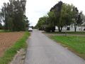
Left the car ...
... and continued on foot.
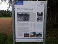
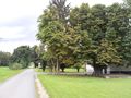
The Sulzbach agriculture. Lecture on the way.
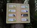
Didn't see one of them.
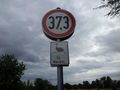
What now?
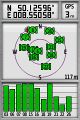
Coordinates ...
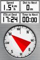
... reached.
Look at the hash.
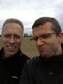
Stupid grin.
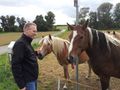
QuarterCacher communicating. Not sure who's getting the tongue ...


Achievements
Mampfred and QuarterCacher earned the Land geohash achievement
|