Difference between revisions of "2011-09-22 45 -121"
From Geohashing
imported>Kydlt |
imported>Kydlt (→Photos) |
||
| Line 32: | Line 32: | ||
Image:2011-09-22 45 -121 flag.jpg |I was here. | Image:2011-09-22 45 -121 flag.jpg |I was here. | ||
Image:2011-09-22 45 -121 gps face.jpg |What a terrible photo. It was glarey & I couldn't see what I was doing. | Image:2011-09-22 45 -121 gps face.jpg |What a terrible photo. It was glarey & I couldn't see what I was doing. | ||
| − | Image:2011-09-22 | + | Image:2011-09-22 24 -121 Capture of track.JPG |This is a screen capture of my track displayed on the laptop. |
</gallery> | </gallery> | ||
Revision as of 03:43, 23 September 2011
{
| Thu 22 Sep 2011 in 45,-121: 45.6807443, -121.8521663 geohashing.info google osm bing/os kml crox |

Location
Cascade Locks
Participants
Plans
I have a hike planed on the Oregon side today, but the Hash looks to be right in Cascade Locks. I think that I'll go on the way.
Expedition
A quick jump into the bushes by the tracks. It wasn't really the empty looking spot that was on the DOQQ. But it was only 20 ft in. I went at about 10 AM & left the marker, but I left the camera in the car. So I stopped on the way back through after a lovely hike up Eagle Creek to Loowit Falls.
Tracklog
A shot in the dark at leaving a tracklog, as a csv-txt file.That didn't work. What form should the link here take ?
Photos
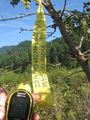
I was here.
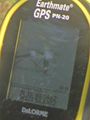
What a terrible photo. It was glarey & I couldn't see what I was doing.
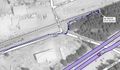
This is a screen capture of my track displayed on the laptop.


