Difference between revisions of "2011-10-09 42 -88"
imported>NWoodruff |
imported>Eldin m (clean up template and check categories.) |
||
| Line 1: | Line 1: | ||
| − | |||
| − | |||
| − | |||
| − | |||
| − | |||
| − | |||
| − | |||
| − | |||
| − | |||
{{meetup graticule | {{meetup graticule | ||
| lat=42 | | lat=42 | ||
| Line 14: | Line 5: | ||
}} | }} | ||
| − | |||
== Location == | == Location == | ||
| − | |||
Some kind of field in Harvard, IL across from a school. | Some kind of field in Harvard, IL across from a school. | ||
== Participants == | == Participants == | ||
| − | |||
| − | [[User:RocketMac|RocketMac]] | + | * [[User:RocketMac|RocketMac]] |
== Plans == | == Plans == | ||
| − | |||
One Sunday a month, I travel down from Greenfield, IL to Oakwood Hills, IL for gaming with friends. I had already checked the day's coordinates on Friday and found an alternate route to my friends that passed by the hashpoint without too much of a delay. | One Sunday a month, I travel down from Greenfield, IL to Oakwood Hills, IL for gaming with friends. I had already checked the day's coordinates on Friday and found an alternate route to my friends that passed by the hashpoint without too much of a delay. | ||
== Expedition == | == Expedition == | ||
| − | |||
My original hope was to earn a TRON Achievement, so I started my track recorder as I pulled out of the driveway. The drive from Greenfield to Harvard proved simple enough. Just South of the Illinois border, I stopped to try to find a geocache, but based on my own experience and recent logs, it has gone missing. That's one advantage of geohashing; they never go missing. | My original hope was to earn a TRON Achievement, so I started my track recorder as I pulled out of the driveway. The drive from Greenfield to Harvard proved simple enough. Just South of the Illinois border, I stopped to try to find a geocache, but based on my own experience and recent logs, it has gone missing. That's one advantage of geohashing; they never go missing. | ||
| Line 49: | Line 35: | ||
== Photos == | == Photos == | ||
| − | |||
| − | |||
| − | |||
<gallery perrow="5"> | <gallery perrow="5"> | ||
Image:2011-10-09 42 -88 01.jpg | East | Image:2011-10-09 42 -88 01.jpg | East | ||
| Line 62: | Line 45: | ||
== Achievements == | == Achievements == | ||
{{#vardefine:ribbonwidth|800px}} | {{#vardefine:ribbonwidth|800px}} | ||
| − | |||
{{land geohash | {{land geohash | ||
| latitude = 42 | | latitude = 42 | ||
| Line 70: | Line 52: | ||
| image = | | image = | ||
}} | }} | ||
| − | |||
| − | |||
| − | |||
| − | |||
| − | |||
| − | |||
| − | |||
| − | |||
| − | |||
| − | |||
[[Category:Expeditions]] | [[Category:Expeditions]] | ||
[[Category:Expeditions with photos]] | [[Category:Expeditions with photos]] | ||
| − | |||
| − | |||
| − | |||
| − | |||
| − | |||
| − | |||
[[Category:Coordinates reached]] | [[Category:Coordinates reached]] | ||
| − | |||
| − | |||
| − | |||
| − | |||
| − | |||
| − | |||
| − | |||
| − | |||
| − | |||
Revision as of 02:33, 12 April 2013
| Sun 9 Oct 2011 in 42,-88: 42.4032732, -88.6177873 geohashing.info google osm bing/os kml crox |
Location
Some kind of field in Harvard, IL across from a school.
Participants
Plans
One Sunday a month, I travel down from Greenfield, IL to Oakwood Hills, IL for gaming with friends. I had already checked the day's coordinates on Friday and found an alternate route to my friends that passed by the hashpoint without too much of a delay.
Expedition
My original hope was to earn a TRON Achievement, so I started my track recorder as I pulled out of the driveway. The drive from Greenfield to Harvard proved simple enough. Just South of the Illinois border, I stopped to try to find a geocache, but based on my own experience and recent logs, it has gone missing. That's one advantage of geohashing; they never go missing.
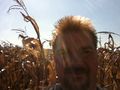
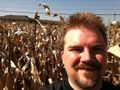
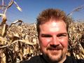
Continuing South, pulled up on the side of the road near Richard D Crosby Elementary School. The hashpoint was in a corn field across the street. Standing next to a telephone/power pole, I made sure I was a close to the point before going in as possible. I also made sure that no cars were in sight before stepping in just in case someone would object to my probable trespassing.
Standing there, I was only 17 yards away, but I was determined to be right on the spot. Wading in, I started having flashbacks to visiting family farms as a kid as well as images of horror movie scenes. At last it was daytime.
After a little bit of wandering, I was there. I snapped a few pictures, one from each cardinal directions showing that I was, in fact, surrounded by corn.
On my way out, I slowed down as I reached the edge of the field, so I could listen for approaching cars. Once the coast was clear, I popped on. No sooner had I crossed the street and was back at my car, a police car drove by. Good timing.
From there, I continued on to my friends' place. My GPS gave me a different route home which I thought would help with my TRON achievement. When I checked, I only crossed the line once when I was flipping a U-turn after the hash. Drats!
Tracklog
My log for the whole day is available in GPX and KMZ formats
Photos

East
South
West
North
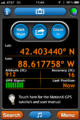
GPS


Achievements
RocketMac earned the Land geohash achievement
|