Difference between revisions of "2011-12-11 42 -87"
From Geohashing
imported>RocketMac (→Expedition) |
imported>RocketMac |
||
| Line 63: | Line 63: | ||
| image = | | image = | ||
}} | }} | ||
| + | {{Hash collision | ||
| + | | latitude = 42 | ||
| + | | longitude = -87 | ||
| + | | date = 2011-12-11 | ||
| + | | name = [[User:RocketMac|RocketMac]] | ||
| + | | id = GC349X9 | ||
| + | | link = | ||
| + | | distance = 696 feet | ||
| + | | image = | ||
| + | | honor = honorable mention | ||
| + | }} | ||
| + | |||
<!-- =============== USEFUL CATEGORIES FOLLOW ================ | <!-- =============== USEFUL CATEGORIES FOLLOW ================ | ||
Revision as of 04:16, 12 December 2011
| Sun 11 Dec 2011 in 42,-87: 42.0252033, -87.7043083 geohashing.info google osm bing/os kml crox |
Location
The first baseline of a nice park with a sled hill down the line
Participants
RocketMac - A slight detour (44.6 miles) to visiting friends in Oakwood Hills.
Plans
Both the 42,-88 and 42,-87 graticules were possible detours to spend the day with friends, but this one I had not yet visited. Normally, I leave the house at 10am to visit friends at noon once a month, but this time I left an hour early to make the hashpoint with time to make it.
Expedition
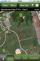
GC349X9 - Adventures of the P^2’s – Part 2
Tracklog
Photos

Stupid Grin
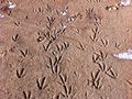
OMG! RAPTOR TRACKS!
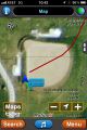
Map
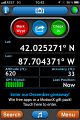
GPS
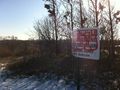
Hey look! A geocache nearby!

It's way back there!
Top of the sled hill
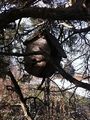
The cache is a fake bird house
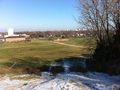
Hashpoint from the top of the sled hill


Achievements
RocketMac earned the Land geohash achievement
|
RocketMac earned the Hash collision honorable mention
|