Difference between revisions of "2011-12-31 50 13"
From Geohashing
imported>TheOneRing (→Photos) |
imported>TheOneRing (→TheOneRing) |
||
| Line 35: | Line 35: | ||
== Achievements == | == Achievements == | ||
=== TheOneRing === | === TheOneRing === | ||
| − | + | {{land geohash | latitude = 50 | longitude = 13 | date = 2011-12-31 | name = TheOneRing }} | |
[[Category:Expeditions]] | [[Category:Expeditions]] | ||
| + | [[Category:Expeditions with photos]] | ||
[[Category:Coordinates reached]] | [[Category:Coordinates reached]] | ||
Revision as of 20:19, 4 January 2012
| Sat 31 Dec 2011 in 50,13: 50.9315669, 13.9365828 geohashing.info google osm bing/os kml crox |
Contents
Location
On a field near Pirna.
Who Went
- TheOneRing
- one friend
The Expedition
TheOneRing
Last day of the year, last geohash of the year. Once again I was visiting a friend and the geohash was really nearby, so we decided to go.
We went by car to be fast, otherwise our time table for New Year's Eve would have been a mess. We followed the road until a prohibition sign, the rest was walking. The weather was ok, cloudy but not raining anymore. The geohash itself was on a field, which was quite muddy after the last rainy days, but fortunately, we wore gumboots.
After taking the usual photographs (including stupid grins, of course) we drove back.
Photos
TheOneRing
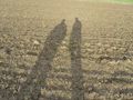
Two hashers looking for the geohash
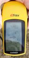
Exactly here...
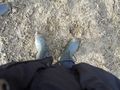
...in a muddy field
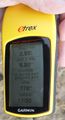
Some additional information
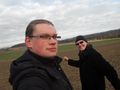
Two StupidGrins
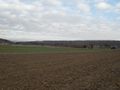
Muddy fields over...
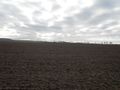
...and over
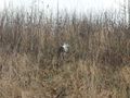
A hash cat


Achievements
TheOneRing
TheOneRing earned the Land geohash achievement
|