Difference between revisions of "2012-01-29 60 15"
imported>Cjk (→Photos) |
imported>Cjk |
||
| Line 1: | Line 1: | ||
| − | + | [[Image:{{{image|2012-01-29_60_15_15-00-57-146.jpg}}}|thumb|left]] | |
| − | |||
| − | |||
| − | [[Image:{{{image| | ||
| − | |||
| − | |||
| − | |||
| − | |||
| − | |||
| − | |||
{{meetup graticule | {{meetup graticule | ||
| lat=60 | | lat=60 | ||
| Line 19: | Line 10: | ||
== Location == | == Location == | ||
<!-- where you've surveyed the hash to be --> | <!-- where you've surveyed the hash to be --> | ||
| + | 450 m from a logging road into the woods, NW of Fagersta. | ||
== Participants == | == Participants == | ||
<!-- who attended --> | <!-- who attended --> | ||
| + | *[[User:Cjk|Carl-Johan]] | ||
== Plans == | == Plans == | ||
<!-- what were the original plans --> | <!-- what were the original plans --> | ||
| + | Since todays latitude was really low, that meant that [[Sandviken, Sweden]] and [[Falun, Sweden]] was reachable to fill up my minesweeper achievement. So the plan was to drive like [https://maps.google.com/maps?saddr=Unknown+road&daddr=59.3322502,18.0190163+to:59.3568681,17.8759693+to:STORLJUSEN+109,+733+99+M%C3%B6klinta,+Sweden+to:60.11199,16.04703+to:59.99535,15.80814+to:Unknown+road+to:Stora+Essingen,+Sweden&hl=en&ie=UTF8&ll=59.949509,16.787109&spn=2.082477,4.42749&sll=60.006539,15.746155&sspn=0.129922,0.276718&geocode=FWJViQMd7_YSAQ%3BFZpWiQMdyPISASl1Wgm6KnZfRjHR_5MjxFC_yw%3BFcS2iQMdAcQQASmFApFDKp5fRjFQjsAY8_4AEw%3BFfi4kwMdAff6ACk9Lm6DBwxeRjGJy_shGyNLhQ%3BFXY8lQMdttv0ACmrDfEpn-VdRjFwDMAY8_4AEw%3BFdZ0kwMdjDbxACmvBy03DsJdRjGQhdIY8_4AEw%3BFSerkwMd0p_rAA%3BFVIqiQMdzn0SASlJL6EROnZfRjEprsNwAWPNsg&oq=stora+&mra=dpe&mrsp=5&sz=12&via=1,2,4,5&t=m&z=8 this]. | ||
| + | |||
| + | *[[2012-01-29 60 16]] | ||
| + | *[[2012-01-29 60 15]] | ||
== Expedition == | == Expedition == | ||
<!-- how it all turned out. your narrative goes here. --> | <!-- how it all turned out. your narrative goes here. --> | ||
| + | So I came from [[2012-01-29 60 16]], after having lots of fun driving on the frozen lake. Man I need to get me a water geohash and a speed racer in the car at the same time! That would be awesome. | ||
| + | |||
| + | Having been on these roads near Fagersta before I knew that the GPS might throw me on a crazy goose chase again. So I was going to stick to the big main roads even if that would be a bit longer, but probably shorter and a lot faster and safer. So up to Avesta and then down to Fagersta. I knew that the GPS would lead me on a very long logging road so I traded that road for another one which was a lot shorter and then I just needed to hike 50 m more or so. Found out that this was actually a nature reserve but they were still logging like crazy. | ||
| + | |||
| + | I found the road and headed north. Saw a lot of timber on the way, and lots of moose hunting towers. Parked the car just a bit north of planned since the ground was flat there. Saw some human tracks in the snow. A hunter this morning perhaps? Headed into the clear cut which now was filled with pine and spruce about 2 m high at the most. Followed some old machine tracks first and then followed a ridge north. | ||
| + | Still 300 m to go. I saw a lot of fresh moose tracks, and some yellow snow. Took a very nice panorama. Then I found moose droppings, and a place where the moose had lied down, possibly sleeping. Everywhere you went you were crossing moose tracks. Got to the denser part of the forest and by now I was actually making day-glo arrows in the snow if something happened to me. | ||
| + | climbed down a hill, and through some dense spruce. Then up a hill and followed another ridge. At a clearing close to the hash the view was just amazing! There was between 10 and 15 cm of snow everywhere. Walked the last bit and found the hash in among the pines. Of course there was moose tracks just were the geohash was. They already knew it was gonna be there. Took some pictures and marked the snow a tree. Geohashdroid messed up the coords on some of the pictures since I turned the phone sideways and it lost GPS as usual. I should talk to the coder. | ||
| + | |||
| + | *The moose was here before me -- [[User:Cjk|Carl-Johan]] [http://www.openstreetmap.org/?lat=60.01263759&lon=15.44756373&zoom=16&layers=B000FTF @60.0126,15.4476] 08:55, 29 January 2012 (EST) | ||
| + | |||
| + | I started heading back to the car, and decided to try the high route since that part of the forest seemed a lot older and less dense. Had to scale a cliff a bit, but not crazy steep, just very steep. This was a good move since this was much easier. As usual the clear cut was the hardest part to traverse, very uneven, but at least it was pretty. Got back to the car and started doing a 7-point turn on the very narrow road. Though I had turned it around enough when... | ||
| + | |||
| + | DISASTER! What looked like snow covered road turned out to be snow covered ditch. The right side wheels slide down into it and the car get stuck, and the left front wheel just spins. I'm stuck, in the middle of nowhere, and the sun has just gone over the horizon, and it is -6 C already and going down. I don't have my snow chains with me, but I do have my trusty shovel in the trunk. So I shovel trenches and free the car so it can move. And I gather heater to put under the left wheel for traction. I get the car moving backwards and forwards. Sometimes it gets stuck again and the left wheel starts to dig down into the dirt. I have to jump out and dig some more snow. And cycle is repeated many many times. Sometimes I think I might be able to get the car free going forwards but when I turn the wheel left it just start spinning and starts melting snow. Eventually I have a fairly long trench dug fairly free of snow, and I try gunning it backwards. I manage to get the rear to start moving up onto the road, and I gun it some more and eventually the whole car pops backwards up onto the road. Mother Nature is my BITCH! | ||
| + | |||
| + | Pop back in the car after a few photos and head back to safety on the 66 and E18. | ||
| − | |||
== Tracklog == | == Tracklog == | ||
<!-- if your GPS device keeps a log, you may post a link here --> | <!-- if your GPS device keeps a log, you may post a link here --> | ||
| Line 102: | Line 113: | ||
<!-- =============== USEFUL CATEGORIES FOLLOW ================ | <!-- =============== USEFUL CATEGORIES FOLLOW ================ | ||
Delete the next line ONLY if you have chosen the appropriate categories below. If you are unsure, don't worry. People will read your report and help you with the classification. --> | Delete the next line ONLY if you have chosen the appropriate categories below. If you are unsure, don't worry. People will read your report and help you with the classification. --> | ||
| − | |||
| − | |||
<!-- Potential categories. Please include all the ones appropriate to your expedition --> | <!-- Potential categories. Please include all the ones appropriate to your expedition --> | ||
<!-- If this is a planning page: | <!-- If this is a planning page: | ||
| Line 116: | Line 125: | ||
[[Category:Expedition without GPS]] | [[Category:Expedition without GPS]] | ||
--> | --> | ||
| − | + | [[Category:Expeditions]] | |
| + | |||
| + | [[Category:Expeditions with photos]] | ||
| + | |||
<!-- if you reached your coords: | <!-- if you reached your coords: | ||
[[Category:Coordinates reached]] | [[Category:Coordinates reached]] | ||
--> | --> | ||
| + | [[Category:Coordinates reached]] | ||
<!-- or if you failed :( | <!-- or if you failed :( | ||
Revision as of 23:30, 29 January 2012

| Sun 29 Jan 2012 in 60,15: 60.0125897, 15.4476091 geohashing.info google osm bing/os kml crox |
Location
450 m from a logging road into the woods, NW of Fagersta.
Participants
Plans
Since todays latitude was really low, that meant that Sandviken, Sweden and Falun, Sweden was reachable to fill up my minesweeper achievement. So the plan was to drive like this.
Expedition
So I came from 2012-01-29 60 16, after having lots of fun driving on the frozen lake. Man I need to get me a water geohash and a speed racer in the car at the same time! That would be awesome.
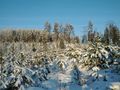
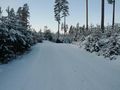
Having been on these roads near Fagersta before I knew that the GPS might throw me on a crazy goose chase again. So I was going to stick to the big main roads even if that would be a bit longer, but probably shorter and a lot faster and safer. So up to Avesta and then down to Fagersta. I knew that the GPS would lead me on a very long logging road so I traded that road for another one which was a lot shorter and then I just needed to hike 50 m more or so. Found out that this was actually a nature reserve but they were still logging like crazy.
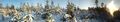
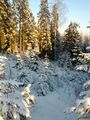
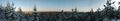
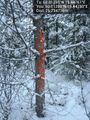
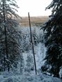
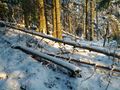
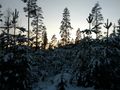
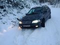
I found the road and headed north. Saw a lot of timber on the way, and lots of moose hunting towers. Parked the car just a bit north of planned since the ground was flat there. Saw some human tracks in the snow. A hunter this morning perhaps? Headed into the clear cut which now was filled with pine and spruce about 2 m high at the most. Followed some old machine tracks first and then followed a ridge north. Still 300 m to go. I saw a lot of fresh moose tracks, and some yellow snow. Took a very nice panorama. Then I found moose droppings, and a place where the moose had lied down, possibly sleeping. Everywhere you went you were crossing moose tracks. Got to the denser part of the forest and by now I was actually making day-glo arrows in the snow if something happened to me.
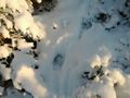
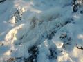
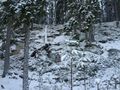
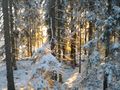
climbed down a hill, and through some dense spruce. Then up a hill and followed another ridge. At a clearing close to the hash the view was just amazing! There was between 10 and 15 cm of snow everywhere. Walked the last bit and found the hash in among the pines. Of course there was moose tracks just were the geohash was. They already knew it was gonna be there. Took some pictures and marked the snow a tree. Geohashdroid messed up the coords on some of the pictures since I turned the phone sideways and it lost GPS as usual. I should talk to the coder.
- The moose was here before me -- Carl-Johan @60.0126,15.4476 08:55, 29 January 2012 (EST)
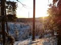
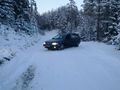
I started heading back to the car, and decided to try the high route since that part of the forest seemed a lot older and less dense. Had to scale a cliff a bit, but not crazy steep, just very steep. This was a good move since this was much easier. As usual the clear cut was the hardest part to traverse, very uneven, but at least it was pretty. Got back to the car and started doing a 7-point turn on the very narrow road. Though I had turned it around enough when...
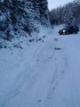
DISASTER! What looked like snow covered road turned out to be snow covered ditch. The right side wheels slide down into it and the car get stuck, and the left front wheel just spins. I'm stuck, in the middle of nowhere, and the sun has just gone over the horizon, and it is -6 C already and going down. I don't have my snow chains with me, but I do have my trusty shovel in the trunk. So I shovel trenches and free the car so it can move. And I gather heater to put under the left wheel for traction. I get the car moving backwards and forwards. Sometimes it gets stuck again and the left wheel starts to dig down into the dirt. I have to jump out and dig some more snow. And cycle is repeated many many times. Sometimes I think I might be able to get the car free going forwards but when I turn the wheel left it just start spinning and starts melting snow. Eventually I have a fairly long trench dug fairly free of snow, and I try gunning it backwards. I manage to get the rear to start moving up onto the road, and I gun it some more and eventually the whole car pops backwards up onto the road. Mother Nature is my BITCH!
Pop back in the car after a few photos and head back to safety on the 66 and E18.
Tracklog
Photos
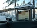
Nature reserve
Yeah it's frozen
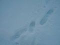
Hunter tracks
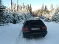
Car parked
Fresh moose tracks
Somewhere in there

300 m to go, sun in my back
Same spot, looking east.
A moose bed last night?
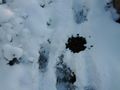
Moose shit
Getting tighter
The view, getting close @60.0120,15.4482
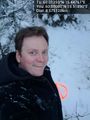
Stupid grin @60.0126,15.4476
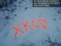
Marker @60.0126,15.4476
Marked tree @60.0126,15.4476
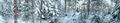
Panorama 1 @60.0126,15.4476

Panorama 2 @60.0125,15.4476
I can scale that, easy
Lone dead tree
Sun creeping back
Storms have taken its toll
Here comes the sun
Back to car
And sun has set here
Fuck, didn't see the ditch, it just looked flat.
MNIMB!!!
The tracks of me going backwards and forwards.


Achievements