Difference between revisions of "2012-02-18 -40 175"
imported>Greenslime m (+ 1 hash attempt) |
imported>FippeBot m (Location) |
||
| Line 42: | Line 42: | ||
[[Category:Coordinates not reached]] | [[Category:Coordinates not reached]] | ||
[[Category:Not reached - No public access]] | [[Category:Not reached - No public access]] | ||
| + | {{location|NZ|MWT}} | ||
Latest revision as of 04:30, 6 August 2019
| Sat 18 Feb 2012 in -40,175: -40.3629672, 175.7616397 geohashing.info google osm bing/os kml crox |
Location
Just off a road, in the back blocks of Palmerston North, New Zealand
Participants
- Greenslime
- Lil Homie
Plans
Drive there, take photos, enjoy.
Expedition
I had a feeling this might end badly as I turned off the smooth tar-seal onto a gravel road. The particle size of the gravel was huge, and my car didn't like it much at all. I persevered along the road bumpily for 6 km at 30 km per hour, enjoying the emerging view of Palmerston North and the increasing abundance of wind turbines along the farmland ridge-lines.
After reaching a sign that said Public Road, I wondered why bother announcing that as I assumed the road I was just on was also public. After 100 m I understand the potential confusion as this 'track' had the appearance of a farm road and was clearly not maintained on a regular basis.
I cut my losses early on this as I approached an obstacle early on that my delicate car wouldn't have managed. If I had been more forward thinking and prepared, I would have run the remaining 5 km to the hash, however, with just jandles, and without sunscreen, I declined to take on that challenge.
Photos
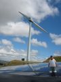
Lill homie along for the ride!
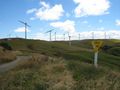
Public road - but they neglected to mention the 4WD bit

