Difference between revisions of "2012-02-26 50 8"
imported>Mampfred m |
imported>Mampfred (Report done => Mampfred) |
||
| Line 27: | Line 27: | ||
== Tracklog == | == Tracklog == | ||
=== Mampfred === | === Mampfred === | ||
| − | + | See [http://www.everytrail.com/view_trip.php?trip_id=1464128 here]. | |
== Photos == | == Photos == | ||
| Line 35: | Line 35: | ||
</gallery> | </gallery> | ||
=== Mampfred === | === Mampfred === | ||
| − | + | <gallery perrow=5> | |
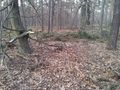
| + | Image:201202-26_50_8_to_the_hash.jpg | The hash should be straight ahead on this track ... | ||
| + | Image:201202-26_50_8_right_this_way.jpg | ... this track to be precise. At least OSM is showing a track here ... | ||
| + | Image:201202-26_50_8_wo_ein_wille.jpg | ... ah, this track they mean :) | ||
| + | Image:201202-26_50_8_coordinates.jpg | Coordinates ... | ||
| + | Image:201202-26_50_8_reached.jpg | ... reached. | ||
| + | Image:201202-26_50_8_hash.jpg | Looking at the hash. | ||
| + | Image:201202-26_50_8_grin.jpg | Stupid grin. | ||
| + | </gallery> | ||
== Achievements == | == Achievements == | ||
Revision as of 17:27, 26 February 2012
| Sun 26 Feb 2012 in 50,8: 50.0000466, 8.4837187 geohashing.info google osm bing/os kml crox |
Location
In the woods next to the Autobahn close to Rüsselsheim.
Participants
Plans
Mampfred
Coming from a tap dance seminar mentioned here this also is conventiently close to the Autobahn which makes it a prime candidate for the second part of a multihash.
Expedition
QuarterCacher and M
They went there first ...
Mampfred
QuarterCacher had already texted me that he'd been to todays 50 8 but since I had a multihash to do I went anyway. QuarterCacher was nice enough to also text me the coordinated to the nearest parking lot so I headed straight there and started walking. The hash was easily reached and about 1.8 km away from the parking lot.
Tracklog
Mampfred
See here.
Photos
QuarterCacher and M

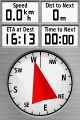
Coordinates reached. @50.0003,8.4838

Mampfred
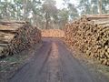
The hash should be straight ahead on this track ...
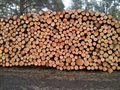
... this track to be precise. At least OSM is showing a track here ...
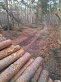
... ah, this track they mean :)
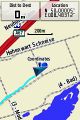
Coordinates ...
... reached.
Looking at the hash.

Stupid grin.


Achievements
- Land
- QuarterCacher and M: Earliest Geohasher
- Mampfred: Multihash x 2