Difference between revisions of "2012-03-10 34 -118"
From Geohashing
imported>S0meb0dy (→Plans) |
imported>S0meb0dy (→Achievements) |
||
| Line 47: | Line 47: | ||
{{#vardefine:ribbonwidth|800px}} | {{#vardefine:ribbonwidth|800px}} | ||
<!-- Add any achievement ribbons you earned below, or remove this section --> | <!-- Add any achievement ribbons you earned below, or remove this section --> | ||
| − | + | {{No trespassing | latitude = 34 | longitude = -118 | date = 2012-03-10 | name = s0meb0dy }} | |
<!-- =============== USEFUL CATEGORIES FOLLOW ================ | <!-- =============== USEFUL CATEGORIES FOLLOW ================ | ||
Revision as of 01:02, 13 March 2012
| Sat 10 Mar 2012 in 34,-118: 34.2001308, -118.3999547 geohashing.info google osm bing/os kml crox |
Location
Participants
Plans
I looked at this on Friday and all appeared ok. Didn't notice the fence on the google map sat image.
Expedition
The geohash was half way down the alley in the pic below. Does 200ft away count as making it? I think I'll have to mark this as a No Trespassing Achievement instead. s0meb0dy
Tracklog
Photos
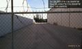
Almost there. Missed it by 200 feet. @34.2007,-118.4000

Achievements
s0meb0dy earned the No trespassing consolation prize
|