Difference between revisions of "2012-03-11 51 11"
imported>TheOneRing (→TheOneRing) |
imported>FippeBot m (Location) |
||
| Line 34: | Line 34: | ||
[[Category:Expeditions with photos]] | [[Category:Expeditions with photos]] | ||
[[Category:Coordinates reached]] | [[Category:Coordinates reached]] | ||
| + | {{location|DE|ST|HAL}} | ||
Latest revision as of 02:51, 13 August 2019
| Sun 11 Mar 2012 in 51,11: 51.4383395, 11.9653020 geohashing.info google osm bing/os kml crox |
Contents
Location
The geohash is in Halle-Silberhöhe.
Who went
TheOneRing - by car.
The Expedition
TheOneRing
If I wasn't hiking that day, it would have been a perfect opportunity to get another walk geohash. But if-cases don't count and hiking is always fun, so I had to adjust my plans. I decided to go on my way back to Halle, a small detour led me to the geohash. The car parked ca. 500m from the geohash but no one else wanted to step off the car and I had to walk alone. In fact it was nothing really special: a high density housing area from the 60s and 70s. These houses are quite typical for districts built in that era.
I took the usual photographs went back home by car again.
Photos
TheOneRing
Coordinates reached
Some additional information
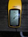
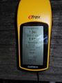
My eTrex marks the geohash
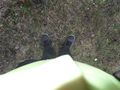
Standing on the geohash...
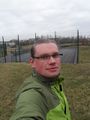
...and grinning (somehow stupid)
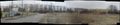
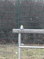
Panoramic view


Achievements
TheOneRing earned the Land geohash achievement
|