Difference between revisions of "2012-03-31 53 -2"
imported>Angel (→Expedition) |
imported>Angel |
||
| Line 1: | Line 1: | ||
| − | |||
<!-- If you did not specify these parameters in the template, please substitute appropriate values for IMAGE, LAT, LON, and DATE (YYYY-MM-DD format) | <!-- If you did not specify these parameters in the template, please substitute appropriate values for IMAGE, LAT, LON, and DATE (YYYY-MM-DD format) | ||
| − | [[Image:{{{image| | + | [[Image:{{{image|2012-03-31_53_-2_16-10-00-400.jpg}}}|thumb|left]] |
Remove this section if you don't want an image at the top (left) of your report. You should remove the "Image:" or "File:" | Remove this section if you don't want an image at the top (left) of your report. You should remove the "Image:" or "File:" | ||
| Line 18: | Line 17: | ||
__NOTOC__ | __NOTOC__ | ||
== Location == | == Location == | ||
| − | + | Wrightington, just off Mossy Lea Lane. | |
== Participants == | == Participants == | ||
| − | + | * [[User:Angel|Angel]] | |
| + | * 3 others, whose names and usernames I didn't think to make a note of | ||
== Plans == | == Plans == | ||
| Line 47: | Line 47: | ||
== Achievements == | == Achievements == | ||
{{#vardefine:ribbonwidth|800px}} | {{#vardefine:ribbonwidth|800px}} | ||
| − | |||
| + | {{Meet-up | ||
| + | | latitude = 53 | ||
| + | | longitude = -2 | ||
| + | | date = 2012-03-31 | ||
| + | | name = [[User:Angel|Angel]] | ||
| + | | image = 2012-03-31_53_-2_16-23-58-923.jpg | ||
| + | }} | ||
| − | |||
| − | |||
| − | |||
| − | |||
| − | |||
| − | |||
| − | |||
| − | |||
| − | |||
| − | |||
[[Category:Expeditions]] | [[Category:Expeditions]] | ||
| − | |||
[[Category:Expeditions with photos]] | [[Category:Expeditions with photos]] | ||
| − | |||
| − | |||
| − | |||
| − | |||
| − | |||
[[Category:Coordinates reached]] | [[Category:Coordinates reached]] | ||
| − | |||
| − | |||
| − | |||
| − | |||
| − | |||
| − | |||
| − | |||
| − | |||
| − | |||
| − | |||
Revision as of 14:01, 1 April 2012
| Sat 31 Mar 2012 in 53,-2: 53.6109790, -2.7068086 geohashing.info google osm bing/os kml crox |
Location
Wrightington, just off Mossy Lea Lane.
Participants
- Angel
- 3 others, whose names and usernames I didn't think to make a note of
Plans
- Angel may take any available friend; getting the train to Wigan and then walking up to Euxton Balshaw Lane station via the hash point. Or the other way, depending on convenience. Of course, this depends on being able to afford it.
Expedition
Angel got the train to Wigan then walked up Wigan Road. The lakes near the point (visible on satellite) turned out to be Wrightington Fisheries. Signs indicated that you're supposed to pay to get in, but there was nobody at the desk and the signs were all dated 2009 or earlier. Geohash Droid kept losing GPS signal, unfortunately, so the coordinates on the photo are a bit off. However, the piles of builder's waste (broken bricks and similar) at the edge of the field were distinctive enough on Google Maps satellite to let me be sure I was standing in the right place.
Met 3 other geohashers at the site - but I already forgot their names (Whoops, I'm terrible with names).
Tracklog
Photos
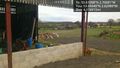
Looks like the right place to me :) @53.6504,-2.6299
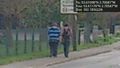
I see other geohashers


Achievements
Angel earned the Meet-up achievement
|