Difference between revisions of "2012-05-05 55 12"
imported>Apatron (Created page with " {{meetup graticule | lat=55 | lon=12 | date=2012-05-05 | graticule_name=Landskrona }}<br style="clear: both"/> __NOTOC__ == Location == A field north of Landskrona, Sweden. ...") |
imported>Apatron |
||
| Line 1: | Line 1: | ||
| + | <!-- If you did not specify these parameters in the template, please substitute appropriate values for IMAGE, LAT, LON, and DATE (YYYY-MM-DD format) | ||
| + | DON'T FORGET to add your expedition and the best photo you took to the gallery on the Main Page! We'd love to read your report, but that means we first have to discover it! :) | ||
| + | --> | ||
{{meetup graticule | {{meetup graticule | ||
| lat=55 | | lat=55 | ||
| lon=12 | | lon=12 | ||
| date=2012-05-05 | | date=2012-05-05 | ||
| − | + | }} | |
| − | }} | ||
| + | <!-- edit as necessary --> | ||
__NOTOC__ | __NOTOC__ | ||
| − | |||
== Location == | == Location == | ||
| − | + | <!-- where you've surveyed the hash to be -->Field north of Landskrona, Sweden. The area is called Glumslöv Hills. It's a very beautiful, scenic, hilly area right next to the sea. | |
== Participants == | == Participants == | ||
| − | * [[User: | + | <!-- who attended: If you link to your wiki user name in this section, your expedition will be picked up by the various statistics generated for geohashing. You may use three tildes ~ as a shortcut to automatically insert the user signature of the account you are editing with. |
| + | --> | ||
| + | * [[User:Johan Andersson|Johan Andersson]] | ||
| + | |||
| + | == Plans == | ||
| + | <!-- what were the original plans --> | ||
| + | The plan was to go birding as usual. Had found out about geohashing just the day before. Downloaded an app and saw that this days hash was not only reachable, but just a couple of kilometers north of where I already was planning to go. So I decided to try for it. | ||
== Expedition == | == Expedition == | ||
| − | + | <!-- how it all turned out. your narrative goes here. --> | |
| + | Went there by bike. Walked the last couple of kilometers. The area is known to me since before, but I had never gone to this particular point. | ||
| + | |||
| + | Reached the coordinates without problem. The geohash didn't have a nice view of the ocean, as do most places in this area, but it felt great to reach it. Especially since its only my second day geohashing. Also, most of my graticule is water, and most of the landpart of it is in another country (Denmark). Therefore I will probably have to wait a while for a reachable geohash again. I consider myself very lucky. | ||
| + | |||
| + | |||
| + | == Photos == | ||
| + | <!-- Insert pictures between the gallery tags using the following format: | ||
| + | Image:2010-##-## ## ## Alpha.jpg | Witty Comment | ||
| + | --> | ||
| + | <gallery perrow="5"> | ||
| + | Image:2012-05-05 55 12 On the way.jpg | About a kilometer from the destination | ||
| + | Image:2012-05-05 55 12 On the way view.jpg |A nice view from the way there | ||
| + | Image:2012-05-05 55 12 the hash is out there.jpg | The hashpoint is about 50 meters out in the field in this picture | ||
| + | Image:2012-05-05_55_12_Landskrona_Sweden.jpg | Picture taken from the hashpoint | ||
| + | </gallery> | ||
| + | |||
| + | |||
| + | |||
| + | <!-- =============== USEFUL CATEGORIES FOLLOW ================ | ||
| + | Delete the next line ONLY if you have chosen the appropriate categories below. If you are unsure, don't worry. People will read your report and help you with the classification. --> | ||
| + | [[Category:New report]] | ||
| + | |||
| + | |||
| − | [[Category: Expeditions]] | + | [[Category:Expeditions]] |
| − | [[Category: Coordinates reached]] | + | [[Category:Expeditions with photos]] |
| + | [[Category:Coordinates reached]] | ||
Revision as of 13:43, 6 May 2012
| Sat 5 May 2012 in 55,12: 55.9300117, 12.7941584 geohashing.info google osm bing/os kml crox |
Location
Field north of Landskrona, Sweden. The area is called Glumslöv Hills. It's a very beautiful, scenic, hilly area right next to the sea.
Participants
Plans
The plan was to go birding as usual. Had found out about geohashing just the day before. Downloaded an app and saw that this days hash was not only reachable, but just a couple of kilometers north of where I already was planning to go. So I decided to try for it.
Expedition
Went there by bike. Walked the last couple of kilometers. The area is known to me since before, but I had never gone to this particular point.
Reached the coordinates without problem. The geohash didn't have a nice view of the ocean, as do most places in this area, but it felt great to reach it. Especially since its only my second day geohashing. Also, most of my graticule is water, and most of the landpart of it is in another country (Denmark). Therefore I will probably have to wait a while for a reachable geohash again. I consider myself very lucky.
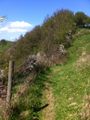
Photos
About a kilometer from the destination

A nice view from the way there

The hashpoint is about 50 meters out in the field in this picture
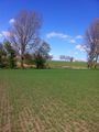
Picture taken from the hashpoint


