Difference between revisions of "2012-05-13 38 23"
imported>Jonas.gbl (→Photos) |
imported>Jonas.gbl (→Photos) |
||
| Line 31: | Line 31: | ||
All photos are GPS-tagged, as a proof of being there at the correct place & date. For some reason Lat/Lon are not shown on the MetaData table. Just download the files to see the coordinates with an external application such as ACDSee. | All photos are GPS-tagged, as a proof of being there at the correct place & date. For some reason Lat/Lon are not shown on the MetaData table. Just download the files to see the coordinates with an external application such as ACDSee. | ||
<gallery perrow="5"> | <gallery perrow="5"> | ||
| − | File:2012-05- | + | File:2012-05-13_38_23_p2.jpg | The geoHash spot |
| − | File:2012-05- | + | File:2012-05-13_38_23_p1.jpg | The geoHash spot in a more artistic photo :P |
| − | File:2012-05- | + | File:2012-05-13_38_23_p3.jpg | A souvenir of the expedition |
| − | File:2012-05- | + | File:2012-05-13_38_23_p4.jpg | A little swim on the way back to celebrate success! |
| − | File:2012-05- | + | File:2012-05-13_38_23_p5.jpg | A little swim on the way back to celebrate success! |
</gallery> | </gallery> | ||
Revision as of 06:59, 14 May 2012
| Sun 13 May 2012 in 38,23: 38.8654550, 23.2888676 geohashing.info google osm bing/os kml crox |
Location
A 10-minutes walk down the river from the waterfall park in Drymwnas, Greece
Participants
Plans
Nothing really to plan! For 2nd consecutive time the geohash spot was just a couple of meters away from one of my cycling roots.
Expedition
Expedition was quite smooth.Cycled 26 km and I was almost there. I just had to walk a couple of meters to the river bank. Some issues finding the actual spot. Limited GPS accuracy, lots of trees.
Tracklog
Photos
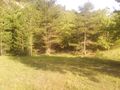
All photos are GPS-tagged, as a proof of being there at the correct place & date. For some reason Lat/Lon are not shown on the MetaData table. Just download the files to see the coordinates with an external application such as ACDSee.
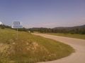
The geoHash spot
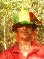
The geoHash spot in a more artistic photo :P
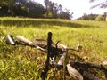
A souvenir of the expedition
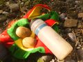
A little swim on the way back to celebrate success!
A little swim on the way back to celebrate success!


Achievements