Difference between revisions of "2010-10-27 47 -122"
imported>Thomcat ((slash) there goes another Ninja!) |
imported>Thomcat (add pics) |
||
| Line 22: | Line 22: | ||
== Photos == | == Photos == | ||
| − | |||
| − | |||
| − | |||
<gallery perrow="5"> | <gallery perrow="5"> | ||
| + | Image:2010-10-27_47_-122_Head2Head.jpg | Approaching - 2 GPS | ||
| + | Image:2010-10-27_47_-122_Android.jpg | Photo with Android | ||
| + | Image:2010-10-27_47_-122_Chalk.jpg | Photo of Android | ||
| + | Image:2010-10-27_47_-122_Thomcat.jpg | Geohasher | ||
</gallery> | </gallery> | ||
Revision as of 21:05, 19 December 2012
| Wed 27 Oct 2010 in 47,-122: 47.8220939, -122.2969168 geohashing.info google osm bing/os kml crox |
Location
The parking lot of a Fred Meyer near Lynnwood.
Participants
Expedition
Time to put this GeohashDroid app to the test. Using only that, I navigated from work to the geohash point, without prior research of it's location. Well, okay, I knew it was more or less on the way home, but not specifically where.
The maps occasionally act a little screwy - zooming in a little too far so your "dot" is off the screen, but overall I was able to find my way there. I must say my well-worn Garmin was more than a little bit jealous - a problem easily solved by unplugging it from power for a few minutes, unfortunately.
As driving in a parking lot and watching the geohash droid screen is *not* recommended, I found a spot to park that was withing 10 meters, then walked out and hoofed it. The cute little app responded by flashing a message when I was closer than accuracy could reflect - found it!
I then grabbed the convenient sidewalk chalk I always carry and marked the spot for posterity - roughly equivalent to three days if it doesn't rain, three hours otherwise.
Photos
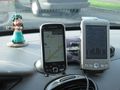
Approaching - 2 GPS
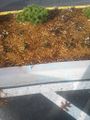
Photo with Android
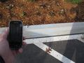
Photo of Android
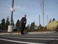
Geohasher


