Difference between revisions of "2008-05-24 53 -1"
imported>Thomcat (Success/failure category added) |
imported>Benjw m (Displaying photos in gallery section rather than full-size on the expedition page.) |
||
| Line 12: | Line 12: | ||
This hash location was in the Derbyshire Dales, in the hills above Matlock Bath. | This hash location was in the Derbyshire Dales, in the hills above Matlock Bath. | ||
| − | + | <gallery widths="160px" align=center> | |
| − | + | Image:2008-05-24_53_-1_a.jpg|The "Heights of Abraham" cable car on the other side of the dale. | |
| − | The "Heights of Abraham" cable car | + | Image:2008-05-24_53_-1_b.jpg|Riber Castle is also nearby, but that's another story. |
| − | + | Image:2008-05-24_53_-1_c.jpg|Some approaches to the location were blocked by nasty signs. | |
| − | + | Image:2008-05-24_53_-1_d.jpg|The town of Matlock. | |
| − | + | Image:2008-05-24_53_-1_e.jpg|A game of Cricket. | |
| − | Riber Castle is also nearby, but that's another story. | + | Image:2008-05-24_53_-1_f.jpg|Stinging nettles made me decide that it wasn't important to get to the ''exact'' coordinates! |
| − | + | Image:2008-05-24_53_-1_g.jpg|This metal shed is the nearest building to the point. You can see it on [http://irc.peeron.com/xkcd/map/map.html?date=2008-05-24&lat=53&long=-2&zoom=17&abs=1 Google Earth]. | |
| − | + | Image:2008-05-24_53_-1_h.jpg|This out-of-focus (sorry) shot shows the remains of the abandoned poly-tunnel greenhouses that can also be seen on the aerial photos. The whole area is pretty overgrown. | |
| − | + | Image:2008-05-24_53_-1_i.jpg|The coordinates are about five or ten metres behind me and to my right, perhaps in line with the stone gate-post. | |
| − | Some approaches to the location were blocked by nasty signs. | + | Image:2008-05-24_53_-1_j.jpg|In total I cycled 57 miles (92km) this afternoon. The sides of the dales are quite steep! |
| − | + | Image:2008-05-24_53_-1_k.jpg|In Matlock Bath there were hundreds of weekend bikers. | |
| − | + | Image:2008-05-24_53_-1_l.jpg|I stopped for fish, chips and a pint of bitter-shandy. The pint was nice, but I could feel it sloshing about all the way back to Nottingham. | |
| − | + | </gallery> | |
| − | The town of Matlock. | ||
| − | |||
| − | |||
| − | |||
| − | A game of Cricket. | ||
| − | |||
| − | |||
| − | |||
| − | Stinging nettles made me decide that it wasn't important to get to the ''exact'' coordinates! | ||
| − | |||
| − | |||
| − | |||
| − | This metal shed is the nearest building to the point. You can see it on [http://irc.peeron.com/xkcd/map/map.html?date=2008-05-24&lat=53&long=-2&zoom=17&abs=1 Google Earth]. | ||
| − | |||
| − | |||
| − | |||
| − | This out-of-focus (sorry) shot shows the remains of the abandoned poly-tunnel greenhouses that can also be seen on the aerial photos. The whole area is pretty overgrown. | ||
| − | |||
| − | |||
| − | |||
| − | The coordinates are about five or ten metres behind me and to my right, perhaps in line with the stone gate-post. | ||
| − | |||
| − | |||
| − | |||
| − | In total I cycled 57 miles (92km) this afternoon. The sides of the dales are quite steep! | ||
| − | |||
| − | |||
| − | |||
| − | In Matlock Bath there were hundreds of weekend bikers. | ||
| − | |||
| − | |||
| − | |||
| − | I stopped for fish, chips and a pint of bitter-shandy. The pint was nice, but I could feel it sloshing about all the way back to Nottingham. | ||
| − | |||
[[Category:Expeditions]] | [[Category:Expeditions]] | ||
[[Category:Expeditions with photos]] | [[Category:Expeditions with photos]] | ||
[[Category:Coordinates reached]] | [[Category:Coordinates reached]] | ||
Revision as of 16:40, 6 February 2009
| Sat 24 May 2008 in Sheffield: 53.1266480, -1.5475331 geohashing.info google osm bing/os kml crox |
On 2008-05-24, in the Sheffield (53,-1) graticule, attendance was in single-figures, even in binary.
This hash location was in the Derbyshire Dales, in the hills above Matlock Bath.
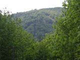
The "Heights of Abraham" cable car on the other side of the dale.
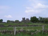
Riber Castle is also nearby, but that's another story.
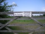
Some approaches to the location were blocked by nasty signs.
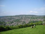
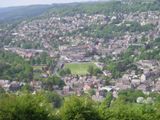
The town of Matlock.
A game of Cricket.
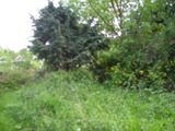
Stinging nettles made me decide that it wasn't important to get to the exact coordinates!
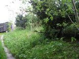
This metal shed is the nearest building to the point. You can see it on Google Earth.
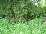
This out-of-focus (sorry) shot shows the remains of the abandoned poly-tunnel greenhouses that can also be seen on the aerial photos. The whole area is pretty overgrown.
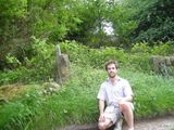
The coordinates are about five or ten metres behind me and to my right, perhaps in line with the stone gate-post.
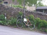
In total I cycled 57 miles (92km) this afternoon. The sides of the dales are quite steep!
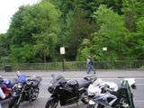
In Matlock Bath there were hundreds of weekend bikers.
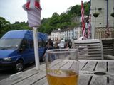
I stopped for fish, chips and a pint of bitter-shandy. The pint was nice, but I could feel it sloshing about all the way back to Nottingham.


