Difference between revisions of "2012-07-13 40 -74"
From Geohashing
imported>Jevanyn ([retro picture] Closest crossroads, just for reference [http://www.openstreetmap.org/?lat=40.56280000&lon=-74.69910000&zoom=16&layers=B000FTF @40.5628,-74.6991]) |
imported>Jevanyn (The GPS features on my phone are pretty close to useless, as it usually can't locate me with a mile.) |
||
| Line 1: | Line 1: | ||
| − | |||
<!-- If you did not specify these parameters in the template, please substitute appropriate values for IMAGE, LAT, LON, and DATE (YYYY-MM-DD format) | <!-- If you did not specify these parameters in the template, please substitute appropriate values for IMAGE, LAT, LON, and DATE (YYYY-MM-DD format) | ||
| Line 18: | Line 17: | ||
__NOTOC__ | __NOTOC__ | ||
== Location == | == Location == | ||
| − | + | Aside a street in Somerset County. (I think it's still within Bridgewater, but I could be wrong.) | |
== Participants == | == Participants == | ||
| − | + | [[User:Jevanyn|Jevanyn]] | |
| − | |||
== Plans == | == Plans == | ||
| − | + | Planning to drive by while running errands. It's only a few miles from home, so it should take me 20-30 minutes out of my way. | |
== Expedition == | == Expedition == | ||
| − | + | ||
*This geohash is only a few miles from home for me, so I drove by while out running errands with the baby. | *This geohash is only a few miles from home for me, so I drove by while out running errands with the baby. | ||
| − | + | -- [[User:Jevanyn|Jevanyn]] 17:48, 17 July 2012 (EDT) | |
| − | |||
| − | |||
== Photos == | == Photos == | ||
| − | |||
| − | |||
| − | |||
<gallery perrow="5"> | <gallery perrow="5"> | ||
| Line 49: | Line 42: | ||
</gallery> | </gallery> | ||
| − | |||
| − | |||
| − | |||
| − | |||
| − | |||
| − | |||
| − | |||
| − | |||
| − | |||
| − | |||
| − | |||
| − | |||
| − | |||
| − | |||
| − | |||
[[Category:Expeditions]] | [[Category:Expeditions]] | ||
| − | |||
[[Category:Expeditions with photos]] | [[Category:Expeditions with photos]] | ||
| − | |||
[[Category:Expedition without GPS]] | [[Category:Expedition without GPS]] | ||
| − | |||
| − | |||
[[Category:Coordinates reached]] | [[Category:Coordinates reached]] | ||
| − | + | [[Category:Jevanyn/brought Grace]] | |
| − | |||
| − | |||
| − | |||
| − | |||
| − | |||
| − | |||
| − | |||
| − | |||
| − | |||
| − | |||
| − | |||
| − | |||
| − | |||
| − | [[Category: | ||
| − | |||
| − | |||
Revision as of 14:30, 18 July 2012
| Fri 13 Jul 2012 in 40,-74: 40.5662695, -74.7369868 geohashing.info google osm bing/os kml crox |
Location
Aside a street in Somerset County. (I think it's still within Bridgewater, but I could be wrong.)
Participants
Plans
Planning to drive by while running errands. It's only a few miles from home, so it should take me 20-30 minutes out of my way.
Expedition
- This geohash is only a few miles from home for me, so I drove by while out running errands with the baby.
-- Jevanyn 17:48, 17 July 2012 (EDT)
Photos
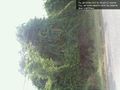
Geohash is right under that tree, give or take a few feet. @40.5628,-74.6991
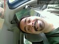
I've been practicing my Silly Grin &tm; @40.5628,-74.6991
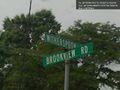
Closest crossroads, just for reference @40.5628,-74.6991


