Difference between revisions of "2012-07-18 33 -116"
imported>LucasBrown (Orthogonal jointing in an exposed bedrock wall) |
imported>LucasBrown (Close-up of the rock in the wall. Six-inch rubber chicken for scale.) |
||
| Line 23: | Line 23: | ||
Image:2012-07-18_33_-116_20-56-57-019.jpg | Orthogonal jointing in an exposed bedrock wall | Image:2012-07-18_33_-116_20-56-57-019.jpg | Orthogonal jointing in an exposed bedrock wall | ||
| + | |||
| + | Image:2012-07-18_33_-116_20-57-54-019.jpg | Close-up of the rock in the wall. Six-inch rubber chicken for scale. | ||
</gallery> | </gallery> | ||
Revision as of 03:58, 19 July 2012
| Wed 18 Jul 2012 in 33,-116: 33.1360210, -116.4769663 geohashing.info google osm bing/os kml crox |
Location
Between the Pacific Crest Trail and Grapevine Canyon Road in the Anza-Borrego Desert
Participants
Expedition
The hasher drove out along State Route 78 to Yaqui Pass Road, followed by a quick left onto Grapevine Canyon Road—an unpaved service road for a telephone line running down the canyon. This road shoots westward for a ways before taking a northwestern bend; this bend, at 1.8 kilometers from the hashpoint, is the closest vehicular approach possible. The hasher thereupon stopped the car and proceeded to attempt the hashpoint by foot, despite the 100-degree temperatures and late hour. Sanity prevailed after about 20 meters, and the hasher returned to the car and went home.
Photos
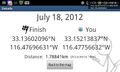
Geohash Droid screenshot at the point where sanity prevailed
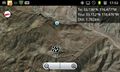
Map at the closest vehicular approach
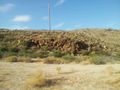
Orthogonal jointing in an exposed bedrock wall
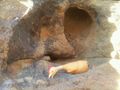
Close-up of the rock in the wall. Six-inch rubber chicken for scale.


Achievements