Difference between revisions of "2012-11-27 48 9"
From Geohashing
imported>Steingesicht (→Achievements) |
imported>FippeBot m (Location) |
||
| Line 28: | Line 28: | ||
[[Category:Expeditions with photos]] | [[Category:Expeditions with photos]] | ||
[[Category:Coordinates reached]] | [[Category:Coordinates reached]] | ||
| + | {{location|DE|BW|RT}} | ||
Latest revision as of 00:02, 14 August 2019
| Tue 27 Nov 2012 in 48,9: 48.5642533, 9.2202787 geohashing.info google osm bing/os kml crox |
Location
Mittelstadt, a small track near the soccer field. Maybe there will be a nice view over the Neckar to Mittelstadt.
Participants
- Steingesicht was there in the evening.
Plans
This is so close to home, that I can't miss, I will try to go in the evening. --Steingesicht 01:34, 27 November 2012 (EST)
Expedition
Just as plannend I was there in the evening, during an 1h gap in my timetable. I had a walk at the Neckar river, reached the hash-point, found a Geocache OCDE7C and collected some datas for openstreetmap. So from my point of view a perfect expedition.
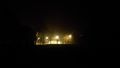
Photos

The soccer field near the hash-point
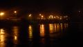
View to the nightly lights of Mittelstadt
View to the soccer field from the hash-point

View to the street
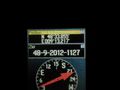
Hash proof


Achievements
none yet