Difference between revisions of "2013-02-02 56 9"
imported>Trulte (→Tracklog) |
imported>Trulte (→Achievements) |
||
| Line 51: | Line 51: | ||
{{#vardefine:ribbonwidth|800px}} | {{#vardefine:ribbonwidth|800px}} | ||
<!-- Add any achievement ribbons you earned below, or remove this section --> | <!-- Add any achievement ribbons you earned below, or remove this section --> | ||
| + | {{land geohash | ||
| + | | latitude = 56 | longitude = 9 | date = 2013-02-02 | ||
| + | }} | ||
| + | |||
| + | {{drag-along | ||
| + | | latitude = 56 | longitude = 9 | date = 2013-02-02 | partner = my husband | ||
| + | }} | ||
| + | |||
| + | {{Earliest geohasher | ||
| + | | latitude = 56 | longitude = 9 | date = 2013-02-02 | ||
| + | }} | ||
| Line 58: | Line 69: | ||
<!-- Potential categories. Please include all the ones appropriate to your expedition --> | <!-- Potential categories. Please include all the ones appropriate to your expedition --> | ||
| − | |||
| − | |||
| − | |||
| − | |||
[[Category:Expeditions]] | [[Category:Expeditions]] | ||
| − | |||
[[Category:Expeditions with photos]] | [[Category:Expeditions with photos]] | ||
| − | + | ||
| − | |||
| − | |||
| − | |||
| − | |||
[[Category:Coordinates reached]] | [[Category:Coordinates reached]] | ||
| − | |||
| − | |||
| − | |||
| − | |||
| − | |||
| − | |||
| − | |||
| − | |||
| − | |||
| − | |||
| − | |||
| − | |||
| − | |||
| − | |||
| − | |||
| − | |||
| − | |||
| − | |||
Revision as of 18:53, 3 February 2013
| Sat 2 Feb 2013 in 56,9: 56.2335908, 9.9685229 geohashing.info google osm bing/os kml crox |
Location
The location was on near a farm house on some fields that would probably be something useful in the summer time, but now in winter was not much.
Participants
Trulte and husband (dragged along for my first geohash)
Plans
We had been on a day trip when I found out that today's hash might be a possible one, and that if we took a detour on the way back home, we could be there just around 4. We arrived at about 4:20, but there were no footprints in the snow indicating that other geohashers had been there before us.
Expedition
As said we were on a day trip to Grenå and took a detour home. The car's GPS helpfully guided us untill it said "continue off road", so we parked along the side of the road and continued on foot, now using the geo hash app on my cell phone. It was probably on private ground as it was some field next to a farmer's house, but as it is winter in Denmark and absolutely no people around at all, we continued closer to the goal.
My hubby said "if someone saw us, they would probably think we were nutcases" and I told him about some of the quotes I had read in here, and agreed that "the internet told us to go here" would probably fit perfectly in this area.
No people arrived though, and suddenly the app said "you're as close as the gps accuracy allows" so I guess that was it! We took some pictures and finished our first ever geo hash.
Tracklog
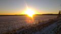
Beatiful sunset on the geo hash. Yes, the sun sets early in Denmark wintertime
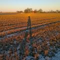
My shadow on the geo hash. Proof enough that I was there?
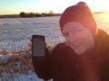
Oh well, here's my stupid grin together with my cell phone supposed to be showing that I'm actually on the right location


Achievements
This user earned the Land geohash achievement
|
This user earned the Drag-along achievement
|
This user earned the Earliest geohasher achievement
|