Difference between revisions of "2013-04-21 55 37"
From Geohashing
imported>Vb (→Tracklog) |
imported>Vb |
||
| Line 1: | Line 1: | ||
| − | |||
| − | |||
| − | |||
| − | |||
| − | |||
| − | |||
| − | |||
| − | |||
| − | |||
| − | |||
{{meetup graticule | {{meetup graticule | ||
| lat=55 | | lat=55 | ||
| Line 19: | Line 9: | ||
== Location == | == Location == | ||
<!-- where you've surveyed the hash to be --> | <!-- where you've surveyed the hash to be --> | ||
| − | In Choboty forest, Novo-Peredelkino district. | + | In Choboty forest, Novo-Peredelkino district. Which is actually, despite being called a forest, is more like a park. |
== Participants == | == Participants == | ||
| Line 43: | Line 33: | ||
--> | --> | ||
<gallery perrow="5"> | <gallery perrow="5"> | ||
| + | Image:2013-04-21 55 37 P1000392.jpg | Rumyantsevo (about half way to the hash) | ||
| + | |||
| + | Image:2013-04-21 55 37 P1000372.jpg | Rumyantsevo still | ||
| + | |||
| + | Image:2013-04-21 55 37 P1000405.jpg | Solntsevo, right next to Rumyantsevo | ||
| + | |||
| + | Image:2013-04-21 55 37 P1000407.jpg | entering the park from Novoperedelkio side | ||
| + | |||
| + | Image:2013-04-21 55 37 P1000412.jpg | destination reached | ||
| + | |||
| + | Image:2013-04-21 55 37 P1000418.jpg | at the hash | ||
| + | |||
| + | Image:2013-04-21 55 37 P1000423.jpg | leaving the park | ||
| + | |||
| + | Image:2013-04-21 55 37 P1000520.jpg | spring it is | ||
</gallery> | </gallery> | ||
Revision as of 21:58, 27 April 2013
| Sun 21 Apr 2013 in 55,37: 55.6455865, 37.3601992 geohashing.info google osm bing/os kml crox |
Location
In Choboty forest, Novo-Peredelkino district. Which is actually, despite being called a forest, is more like a park.
Participants
Plans
To walk, perhaps. Depends on the weather mostly.
Expedition
~18.3km walk, home - hash - some sightseeing - train station
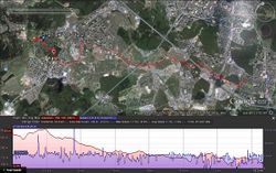
Tracklog
Not completely, but mostly cleared from GPS glitches.


