Difference between revisions of "2013-04-27 50 8"
From Geohashing
imported>Yakamoz (→Photos) |
imported>Rincewind (→Plans) |
||
| Line 15: | Line 15: | ||
== Plans == | == Plans == | ||
| − | To bike 12 km ( | + | To bike 12 km (as the bird flies) from my home to the geohash point and back. |
== Expedition == | == Expedition == | ||
Revision as of 19:55, 27 April 2013
| Sat 27 Apr 2013 in 50,8: 50.5022163, 8.8038107 geohashing.info google osm bing/os kml crox |
Location
On a country road between Lich and Birklar /Hesse
Participants
Plans
To bike 12 km (as the bird flies) from my home to the geohash point and back.
Expedition
This expedition was very exhausting. Continual rain, strong wind, slippery road surfaces and partially no cycle ways. So I came back really tired, wet and cold. It was a good sport acitivity on a bad weather day.
Photos
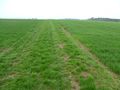
Geohash point
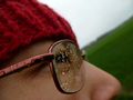
Me at the geohashpoint
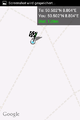
Coordinates reached


Achievements
Yakamoz earned the Land geohash achievement
|
Yakamoz earned the Bicycle geohash achievement
|