Difference between revisions of "2013-05-09 48 11"
From Geohashing
imported>Zertrin (Created page with "{{subst:Expedition |lat = 48 |lon = 11 |date = 2013-05-09 }}") |
imported>Zertrin (report : coords reached) |
||
| Line 1: | Line 1: | ||
| − | |||
| − | |||
| − | |||
| − | |||
| − | |||
| − | |||
| − | |||
| − | |||
| − | |||
| − | |||
{{meetup graticule | {{meetup graticule | ||
| lat=48 | | lat=48 | ||
| Line 18: | Line 8: | ||
__NOTOC__ | __NOTOC__ | ||
== Location == | == Location == | ||
| − | + | In a residential parking alley, in Heimstetten, east of München. | |
== Participants == | == Participants == | ||
| − | + | * [[User:Zertrin|Zertrin]] | |
| − | |||
== Plans == | == Plans == | ||
| − | + | Reactivate the graticule by reaching this quite easy hash. | |
== Expedition == | == Expedition == | ||
| − | + | I went by car, parked near the hash and reached it easily. Took the usual pictures. Went back, the same way. | |
== Tracklog == | == Tracklog == | ||
| − | |||
| − | == Photos == | + | |
| − | + | == Photos == | |
| − | |||
| − | |||
<gallery perrow="5"> | <gallery perrow="5"> | ||
| + | Image:Zertrin_-_2013-05-09_48_11_-_GPS_coords.png | Coords reached | ||
| + | Image:Zertrin - 2013-05-09 48 11 - at the hash point.JPG | [[User:Zertrin|Zertrin]] at the hashpoint | ||
| + | Image:Zertrin - 2013-05-09 48 11 - the hashpoint.JPG | The hashpoint | ||
</gallery> | </gallery> | ||
== Achievements == | == Achievements == | ||
{{#vardefine:ribbonwidth|800px}} | {{#vardefine:ribbonwidth|800px}} | ||
| − | + | {{land geohash | latitude = 48 | longitude = 11 | date = 2013-05-09 | name = [[User:Zertrin|Zertrin]] }} | |
| − | |||
| − | |||
| − | |||
| − | |||
| − | [[ | ||
| − | |||
| − | |||
| − | |||
| − | |||
| − | |||
| − | |||
[[Category:Expeditions]] | [[Category:Expeditions]] | ||
| − | |||
[[Category:Expeditions with photos]] | [[Category:Expeditions with photos]] | ||
| − | |||
| − | |||
| − | |||
| − | |||
| − | |||
[[Category:Coordinates reached]] | [[Category:Coordinates reached]] | ||
| − | |||
| − | |||
| − | |||
| − | |||
| − | |||
| − | |||
| − | |||
| − | |||
| − | |||
| − | |||
| − | |||
| − | |||
| − | |||
| − | |||
| − | |||
| − | |||
| − | |||
| − | |||
Revision as of 17:00, 9 May 2013
| Thu 9 May 2013 in 48,11: 48.1637194, 11.7544208 geohashing.info google osm bing/os kml crox |
Location
In a residential parking alley, in Heimstetten, east of München.
Participants
Plans
Reactivate the graticule by reaching this quite easy hash.
Expedition
I went by car, parked near the hash and reached it easily. Took the usual pictures. Went back, the same way.
Tracklog
Photos
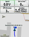
Coords reached
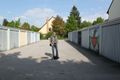
Zertrin at the hashpoint
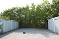
The hashpoint


Achievements
Zertrin earned the Land geohash achievement
|