Difference between revisions of "2013-05-11 54 -2"
imported>Mcbaneg m (Mcbaneg moved page User:Mcbaneg to 2013-05-11 54 -2: expedition report) |
imported>Jiml m (Appease APBot, Result codes look right) |
||
| Line 15: | Line 15: | ||
}} | }} | ||
| − | + | ||
__NOTOC__ | __NOTOC__ | ||
== Location == | == Location == | ||
| Line 21: | Line 21: | ||
== Participants == | == Participants == | ||
| − | George McBane [[User:Mcbaneg|Mcbaneg]] | + | |
| − | Susanne Buchau (official expedition photographer) | + | * George McBane [[User:Mcbaneg|Mcbaneg]] |
| − | Katja McBane | + | * Susanne Buchau (official expedition photographer) |
| − | Rebekah McBane | + | * Katja McBane |
| + | * Rebekah McBane | ||
| Line 36: | Line 37: | ||
== Photos == | == Photos == | ||
| − | + | ||
| − | |||
| − | |||
<gallery perrow="2"> | <gallery perrow="2"> | ||
| Line 54: | Line 53: | ||
<!-- Add any achievement ribbons you earned below, or remove this section --> | <!-- Add any achievement ribbons you earned below, or remove this section --> | ||
| + | * Land Geohash | ||
| − | |||
| − | |||
| − | |||
[[Category:Expeditions]] | [[Category:Expeditions]] | ||
[[Category:Expeditions with photos]] | [[Category:Expeditions with photos]] | ||
[[Category:Expedition without GPS]] | [[Category:Expedition without GPS]] | ||
[[Category:Coordinates reached]] | [[Category:Coordinates reached]] | ||
Revision as of 14:24, 12 May 2013

| Sat 11 May 2013 in 54,-2: 54.8291249, -2.1022332 geohashing.info google osm bing/os kml crox |
Location
A pasture on the northwest bank of Nookton Beck, about 4 miles WSW of Derwent Reservoir, County Durham, UK.
Participants
- George McBane Mcbaneg
- Susanne Buchau (official expedition photographer)
- Katja McBane
- Rebekah McBane
Expedition
Pretty straightforward navigation on rural roads, followed by an easy half mile walk across pasture, in the lovely northern Durham Dales. No GPS, and in this rural valley the smartphone didn't have enough signal to give us a location marker, so once on foot we navigated from memory of the Peeron Map I had studied that morning.
Photos
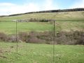
This shot was taken looking SW across Nookton Beck to Crosshill Farm. I have marked two sightlines. On the right the view is nearly in line with a stone wall on the opposite bank. On the left there is a prominent tree on the near side of the beck, and the sightline leads up the hill on the opposite side to the junction between the third and fourth segments of the main farm buildings. These don't meet at the bottom of the image, so their actual intersection must be a little way behind the photographer because of the camera's spherical-to-flat mapping.
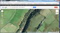
This is the satellite image of the hashpoint area, including the beck and Crosshill Farm. I have marked the same two sightlines on the map; they intersect nearly at the tractor road and wall at the top of the pasture. The photo was taken some way down the hill from that road, nearer the marked hashpoint. A third line marked on the map shows the line of a second stone wall a little farther up the opposite hill. From the site photo it's clear that the line of this second wall passes in front of the photographer, from right to left. My best guess is that the photo was taken from a spot about 80 feet due west of the true hashpoint.


There's a reason wind power is popular around here.
We didn't meet any other geohashers but we did speak with some local residents.

Achievements
- Land Geohash