Difference between revisions of "2013-05-15 43 -116"
From Geohashing
imported>Eldin (Fill in expedition details.) |
imported>Eldin (add picture of GPS coordinates.) |
||
| Line 39: | Line 39: | ||
Image:2013-05-15_43_-116_18-49-07-976.jpg | Houses and trees to the north. | Image:2013-05-15_43_-116_18-49-07-976.jpg | Houses and trees to the north. | ||
| + | |||
| + | Image:2013-05-15 43 -116 proof.jpg | Proof of reaching the coordinates. | ||
</gallery> | </gallery> | ||
Revision as of 01:02, 17 May 2013
| Wed 15 May 2013 in 43,-116: 43.6810543, -116.3124297 geohashing.info google osm bing/os kml crox |
Location
Behind the Walgreens at Horseshoe Bend Rd. and State St. in Eagle, ID.
Participants
Plans
Visit the hash because it was too easy to pass up.
Expedition
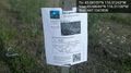
I drove to the hash. I left a poster. I took pictures. Not a terribly exciting expedition. In retrospect, I probably should have bicycled to this one. But I got a later start than I'd hoped due to work, and the route there isn't terribly bicycle friendly.
- At the hashpoint now. Easy one today -- Eldin (talk) @43.6811,-116.3124 18:43, 15 May 2013 (MDT)
Photos

Grin @43.6803,-116.3110
Marker
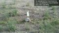
Hashpoint
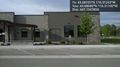
Walgreens to the west.
Clinic to the south.
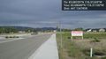
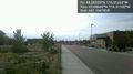
Sign to the east. This hash point is for sale.
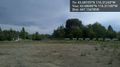
Houses and trees to the north.
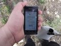
Proof of reaching the coordinates.


Achievements
Eldin earned the Land geohash achievement
|