Difference between revisions of "2013-05-17 46 -118"
imported>Thomcat m (trying to edit on a nook =slow) |
imported>Thomcat (Expedition description; photos coming soon) |
||
| Line 1: | Line 1: | ||
| − | |||
| − | |||
| − | |||
| − | |||
| − | |||
| − | |||
| − | |||
| − | |||
| − | |||
| − | |||
{{meetup graticule | {{meetup graticule | ||
| lat=46 | | lat=46 | ||
| lon=-118 | | lon=-118 | ||
| date=2013-05-17 | | date=2013-05-17 | ||
| + | | graticule_name=Walla Walla | ||
| + | | graticule_link=Walla Walla, Washington | ||
}} | }} | ||
| Line 18: | Line 10: | ||
__NOTOC__ | __NOTOC__ | ||
== Location == | == Location == | ||
| − | + | A farmer's field in Washington, not far from Connell. | |
== Participants == | == Participants == | ||
| − | + | * [[User:Thomcat|Thomcat]] | |
| − | |||
| − | == | + | == Expedition == |
| − | + | Headed out from the Pullman graticule with less preparation, which was worrisome. My original scouting of the graticule showed this to be in a field behind two different small farm houses, so possibly no trespass, but then again near an open space, so possibly accessible. A bit out of the way to fly by the seat of the pants. | |
| − | + | A note on open space - Eastern Washington was carved by flood waters into what is now known as the channeled scablands. What that means for geohashers is that the flat spaces are often farmed (and often inaccessible) and the less flat hills, bluffs and even places where large erratics were deposited are very accessible. The earlier geohash today was an example of that - a hillside that is too steep for reasonable crop farming, but fine for wind farming. | |
| − | + | ||
| + | So, I didn't plan that well, and have no cell service in much of southeastern Washington. Phone GPS (geohashdroid) will get me to the spot, but won't show me terrain without that data download. For the first geohash today, I panned and scanned around the area to have good maps. Here I was flying completely blind. | ||
| + | |||
| + | The car navi system allows me to punch in geo coordinates, which gets me to the road I want. Turns out the road just west of the geohash is unpaved, but accessible - and I don't see any farm houses! I was able to pull to the proper north-south coordinate and ended up parked 120 meters from the hash - across a plowed but unplanted field. Score! | ||
| + | |||
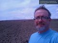
| + | I hiked across the plowed field (which isn't easy to do) and ended up with a very short hash dance to be on the spot. Of course, geohash droid doesn't help me upload (no cell signal) but I took many pictures of the screen. Tomorrow I'll know which turned out and upload accordingly. | ||
| − | + | After that, I headed northwest to Connell, back to civilization (see upload below) and a car wash. | |
| − | |||
== Photos == | == Photos == | ||
Revision as of 05:17, 18 May 2013
| Fri 17 May 2013 in Walla Walla: 46.5083489, -118.8027646 geohashing.info google osm bing/os kml crox |
Location
A farmer's field in Washington, not far from Connell.
Participants
Expedition
Headed out from the Pullman graticule with less preparation, which was worrisome. My original scouting of the graticule showed this to be in a field behind two different small farm houses, so possibly no trespass, but then again near an open space, so possibly accessible. A bit out of the way to fly by the seat of the pants.
A note on open space - Eastern Washington was carved by flood waters into what is now known as the channeled scablands. What that means for geohashers is that the flat spaces are often farmed (and often inaccessible) and the less flat hills, bluffs and even places where large erratics were deposited are very accessible. The earlier geohash today was an example of that - a hillside that is too steep for reasonable crop farming, but fine for wind farming.
So, I didn't plan that well, and have no cell service in much of southeastern Washington. Phone GPS (geohashdroid) will get me to the spot, but won't show me terrain without that data download. For the first geohash today, I panned and scanned around the area to have good maps. Here I was flying completely blind.
The car navi system allows me to punch in geo coordinates, which gets me to the road I want. Turns out the road just west of the geohash is unpaved, but accessible - and I don't see any farm houses! I was able to pull to the proper north-south coordinate and ended up parked 120 meters from the hash - across a plowed but unplanted field. Score!
I hiked across the plowed field (which isn't easy to do) and ended up with a very short hash dance to be on the spot. Of course, geohash droid doesn't help me upload (no cell signal) but I took many pictures of the screen. Tomorrow I'll know which turned out and upload accordingly.
After that, I headed northwest to Connell, back to civilization (see upload below) and a car wash.
Photos
On the grid again; flush with two successes today! @46.6423,-118.8575
