Difference between revisions of "2013-06-08 52 -1"
imported>Nickholden |
imported>Nickholden (→Expedition) |
||
| Line 29: | Line 29: | ||
<!-- how it all turned out. your narrative goes here. --> | <!-- how it all turned out. your narrative goes here. --> | ||
| − | Got lost in Rugby on the way there, and found lots of bonus hills that were not on the route. | + | Got lost in Rugby on the way there, and found lots of bonus hills that were not on the route. The local council presumably decided to save some money by not buying any road signs, on the principle that no-one would venture into Rugby if they didn't absolutely have to, and were absolutely certain of the shortest route in and out. |
| − | On the other hand, got right to the hash point where someone was growing potatoes. And clocked 109km which makes this my longest ride ever. -- [[User:Nickholden|Nickholden]] ([[User talk:Nickholden|talk]]) 22:22, 8 June 2013 (GMT+01:00) | + | And then got lost on the way home leading to an impromptu wander around a golf course. First time I've had the Google Navigation running on my phone - it needs to learn the difference between "a cycle path" and "a place where we might build a cycle path at some point in the future". |
| + | |||
| + | Strange day. On the other hand, got right to the hash point where someone was growing potatoes. And clocked 109km which makes this my longest ride ever. -- [[User:Nickholden|Nickholden]] ([[User talk:Nickholden|talk]]) 22:22, 8 June 2013 (GMT+01:00) | ||
== Tracklog == | == Tracklog == | ||
Revision as of 08:52, 9 June 2013
| Sat 8 Jun 2013 in 52,-1: 52.2897934, -1.3964875 geohashing.info google osm bing/os kml crox |
Location
Long Itchington, Warwickshire. In a farm field off Marton Road.
Participants
Plans
Looks like a nice day for a bike ride. It's also the first day of Strava's "fi'zi:k Tour Tune-Up" so clocking some time in the saddle will be good. Aiming to be at the hashpoint about 4pm, wind and leg muscles permitting.
Expedition
Got lost in Rugby on the way there, and found lots of bonus hills that were not on the route. The local council presumably decided to save some money by not buying any road signs, on the principle that no-one would venture into Rugby if they didn't absolutely have to, and were absolutely certain of the shortest route in and out.
And then got lost on the way home leading to an impromptu wander around a golf course. First time I've had the Google Navigation running on my phone - it needs to learn the difference between "a cycle path" and "a place where we might build a cycle path at some point in the future".
Strange day. On the other hand, got right to the hash point where someone was growing potatoes. And clocked 109km which makes this my longest ride ever. -- Nickholden (talk) 22:22, 8 June 2013 (GMT+01:00)
Tracklog
Getting there: http://app.strava.com/activities/59012356
Getting back: http://app.strava.com/activities/59078582
Photos
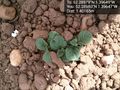
Potatoes!
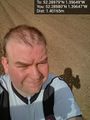
Cheesy grin and a potato field
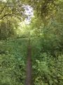
This does not look like a cycle path. And it wasn't. Oops.


