Difference between revisions of "2013-06-30 33 -117"
imported>Scerruti ([live picture] Gratuitous panoramic image from near hash point. [http://www.openstreetmap.org/?lat=33.23090610&lon=-117.28461413&zoom=16&layers=B000FTF @33.2309,-117.2846]) |
imported>Scerruti (Categories reached) |
||
| Line 1: | Line 1: | ||
| − | |||
| − | |||
| − | |||
| − | |||
| − | |||
| − | |||
| − | |||
| − | |||
| − | |||
| − | |||
{{meetup graticule | {{meetup graticule | ||
| lat=33 | | lat=33 | ||
| Line 55: | Line 45: | ||
<!-- Add any achievement ribbons you earned below, or remove this section --> | <!-- Add any achievement ribbons you earned below, or remove this section --> | ||
| − | |||
| − | |||
[[Category:Expeditions]] | [[Category:Expeditions]] | ||
| − | |||
[[Category:Expeditions with photos]] | [[Category:Expeditions with photos]] | ||
| − | + | ||
| − | |||
| − | |||
| − | |||
| − | |||
[[Category:Coordinates reached]] | [[Category:Coordinates reached]] | ||
| − | |||
| − | |||
| − | |||
| − | |||
| − | |||
| − | |||
| − | |||
| − | |||
| − | |||
| − | |||
| − | |||
| − | |||
| − | |||
| − | |||
| − | |||
| − | |||
| − | |||
| − | |||
Revision as of 14:59, 30 June 2013
| Sun 30 Jun 2013 in 33,-117: 33.2266635, -117.2867590 geohashing.info google osm bing/os kml crox |
Location
In the middle of Avenida de la Plata, just off Mesa Drive, in the Rancho del Oro neighborhood of Oceanside, CA.
Participants
Plans
This hash is ideal for a drive-bySpeed Racer or first land geohash achievement. I am hoping to earn the round tripTron and Bicycle Geohash achievements. I will be starting near College and Frazee but I plan to go early to beat the heat. Stephen Cerruti (talk)
Expedition
- Made it! -- Stephen Cerruti (talk) @33.2267,-117.2867 10:32, 30 June 2013 (EDT)
Tracklog
Photos

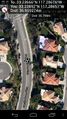
I'm in the middle of the road. This is where Google maps and earth show the hash point to be yet my GPS shows me off in the bushes. I am going to need to figure out which is in error. @33.2268,-117.2870
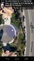
This is a screenshot with me standing where the flag is stuck. @33.2269,-117.2865
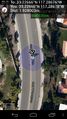
In this picture I am standing on the manhole cover just below my position indicator. This implies that I did previously find the hash point. @33.2266,-117.2870
That's better. @33.2267,-117.2868
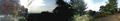
Gratuitous panoramic image from near hash point. @33.2309,-117.2846


