Difference between revisions of "2013-07-12 54 -1"
imported>Mcbaneg |
imported>Mcbaneg |
||
| Line 1: | Line 1: | ||
<!-- If you did not specify these parameters in the template, please substitute appropriate values for IMAGE, LAT, LON, and DATE (YYYY-MM-DD format) | <!-- If you did not specify these parameters in the template, please substitute appropriate values for IMAGE, LAT, LON, and DATE (YYYY-MM-DD format) | ||
| − | [[{{{image| | + | [[{{{image|2013-07-12_54_-1_JKG1_sm.JPG}}}|800px]] |
Remove this section if you don't want an image at the top (left) of your report. You should remove the "Image:" or "File:" | Remove this section if you don't want an image at the top (left) of your report. You should remove the "Image:" or "File:" | ||
| Line 8: | Line 8: | ||
And DON'T FORGET to add your expedition and the best photo you took to the gallery on the Main Page! We'd love to read your report, but that means we first have to discover it! :) | And DON'T FORGET to add your expedition and the best photo you took to the gallery on the Main Page! We'd love to read your report, but that means we first have to discover it! :) | ||
--> | --> | ||
| − | [[Image:{{{image| | + | [[Image:{{{image|2013-07-12_54_-1_JKJ1_sm.JPG}}}|thumb|left]] |
{{meetup graticule | {{meetup graticule | ||
| Line 42: | Line 42: | ||
--> | --> | ||
<gallery perrow="4"> | <gallery perrow="4"> | ||
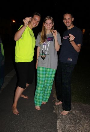
| − | + | Image:2013-07-12_54_-1_JKJ1_sm.JPG | Three honorary hobbits, in pajamas. | |
| + | Image:2013-07-12_54_-1_JKG1_sm.JPG | And a fourth. | ||
| + | Image:2013-07-12_54_-1_Site1_sm.JPG | Our best "proof". The driveway and curb, and the orientation of the corner house at 45 degrees from the streets, and in fact the local resident's red car, are all easily identifiable in the sat map. In fact during the prep Jess thought the car might be a phonebooth and we'd have a shot at another achievement... | ||
</gallery> | </gallery> | ||
Revision as of 08:44, 14 July 2013
| Fri 12 Jul 2013 in 54,-1: 54.7287979, -1.4806282 geohashing.info google osm bing/os kml crox |
Location
The end of a driveway on Malcolm Avenue in Quarrington Hill village, County Durham, UK
Participants
Expedition
We had finished a late pizza-salad-brownie-icecream-cake dinner at about 10 pm, and were hanging out setting up to play Citadels, when Jess saw me looking contemplative and said "you're thinking about going geohashing!" "I was seriously considering it, yeah." "Where is today's?" "In a village just outside Coxhoe, right on the street, about fifteen minutes away; it's easy." "Check to see where tomorrow's is." [pause, fiddling with laptop] "In Bishop Auckland, about 20 minutes away from today's." "Can we hit both, one before midnight and one after?" "Sure." Thus began this evening's silly adventure.
Oh, and another snippet of the conversation: "Did you know there's a Hobbit Hash achievement?" "No way. How does it work?" "You have to go barefoot, fed, and bearing a ring." "We're doing it!"
So today's is just at the end of somebody's driveway, public road, small town, trivial to locate even at 11:40 pm. Shoes off, rings out: four honorary hobbits. (We don't get the actual award because we didn't eat on the way and we didn't walk, but we're claiming a with-Sam-and-Frodo-in-spirit thing here.) Also three of them are wearing pajamas. Return to car, 11:46: off to the next hash, and the date will change while we're on the way.
Photos
Our best "proof". The driveway and curb, and the orientation of the corner house at 45 degrees from the streets, and in fact the local resident's red car, are all easily identifiable in the sat map. In fact during the prep Jess thought the car might be a phonebooth and we'd have a shot at another achievement...
Achievements
George, Katja, Jake, and Jessica earned the Land geohash achievement
|


